
Archived information
The Standard on Web Usability replaces this content. This content is archived because Common Look and Feel 2.0 Standards have been rescinded.
Archived information is provided for reference, research or recordkeeping purposes. It is not subject to the Government of Canada Web Standards and has not been altered or updated since it was archived.
NOTICES TO MARINERS
PUBLICATION
WESTERN EDITION
Safety First, Service Always
Published Monthly by the
CANADIAN COAST GUARD
www.notmar.gc.ca/subscribe/
CONTENTS
| Section 1 | General and Safety Information |
| Section 2 | Chart Corrections |
| Section 3 | Radio Aids to Marine Navigation Corrections |
| Section 4 | Sailing Directions and Small Craft Guide Corrections |
| Section 5 | List of Lights, Buoys and Fog Signals Corrections |
Canadian Coast Guard Programs
Aids to Navigation and Waterways
Fisheries and Oceans Canada
Montreal, Quebec
H2Y 2E7
© Her Majesty the Queen in Right of Canada, 2016
DFO/2016-2003
Fs152-6E-PDF
ISSN 1719-7708
Disponible en français :
Publication des Avis aux navigateurs
Édition de l'Ouest
Édition mensuelle Nº06/2016
Fisheries and Oceans Canada
Official Publication of the Canadian Coast Guard
DFO/2018-2003
EXPLANATORY NOTES
Geographical positions refer directly to the graduations of the largest scale Canadian Hydrographic chart unless otherwise indicated.
Bearings refer to the true compass and are measured clockwise from 000° (North) clockwise to 359°; those relating to lights are from seaward.
Visibility of lights is that in clear weather.
Depths - The units used for soundings (metres, fathoms or feet) are stated in the title of each chart.
Elevations are normally given above Higher High Water, Large Tide unless otherwise indicated.
Distances may be calculated as follows:
1 nautical mile = 1,852 metres (6,076.1 feet)
1 statute mile = 1,609.3 metres (5,280 feet)
1 metre = 3.28 feet
Temporary & Preliminary Notices are indicated by a (T) or a (P) in Section 1, respectively. Please note that Nautical charts are not amended by the Canadian Hydrographic Service for Temporary (T) and Preliminary (P) Notices. It is recommended that mariners chart these corrections in pencil. The list of charts affected by Temporary and Preliminary Notices are revised and promulgated quarterly in Section 1 of the Monthly Edition.
Please note that, in addition to the temporary and preliminary changes normally advertised as (T) and (P) Notices, there are a few permanent changes to aids to navigation that have been advertised as Preliminary Notices to Mariners while charts are being updated for new editions.
Marine Information Report & Suggestion Sheet
Mariners are requested to notify the responsible authorities when new or suspected dangers to navigation are discovered, changes observed in aids to navigation or corrections to publications are seen
to be necessary. Such communications can be made using the Marine Information Report & Suggestion Sheet inserted on the last
page of each monthly edition of Notices to Mariners.
Canadian Hydrographic Service - Information Published in Section 2 of Notices to Mariners
Mariners are advised that only the most critical changes that directly affect safety to navigation are issued in Section 2 – Chart Corrections. This limitation
is required to ensure that charts remain as clear and easy to read as possible. As a result, mariners may see minor discrepancies of a
non-critical nature between information in official publications. For example, a small change in the nominal range or focal height of a light
may not result in the production of a chart correction in Notices to Mariners, but may result in a correction in the List of Lights, Buoys and
Fog Signals publication.
In case of discrepancy between information provided on CHS charts relating to aids to navigation, and the List of Lights, Buoys and Fog Signals publication, the latter shall be deemed as containing the most up-to-date information.
Canadian Nautical Charts & Publications
A source list of Canadian nautical charts and publications is published in Notice No. 14 of the Notices to Mariners Annual Edition 2018. The source supply and the prices
effective at the time of printing are listed. For current chart edition dates, please refer to the following website:
www.chs-shc.gc.ca/charts-cartes/paper-papier/index-eng.asp
CHART CORRECTIONS - SECTION 2
Corrections to nautical charts will be listed in numerical order by chart number. Each chart correction listed applies only to that particular chart. Related charts, if any, will have their own specific correction listed separately.
Users should also refer to CHS Chart 1: Symbols, Abbreviations and Terms for additional information pertaining to the correction of charts.
The illustration below describes the elements that will comprise a typical Section 2 chart correction:
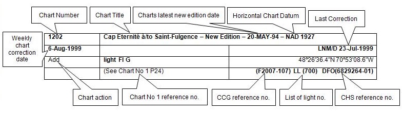
The last correction number is identified with the LNM/D or Last Notice to Mariners Number / Date.
NOTICES TO MARINERS WEBSITE – MONTHLY EDITIONS, CHART CORRECTIONS, AND CHART PATCHES
The Notices to Mariners website allows users to access the monthly publications,
chart corrections, and chart patches.
Users can subscribe for free to the email notification service
to receive notifications when charts of interest are updated, including their patches, as well as when a new monthly edition becomes available online.
ADVISORY NOTICES TO SHIPPING (BROADCAST AND WRITTEN)
The Canadian Coast Guard is implementing a number of changes to the aids to navigation system in Canada.
These changes are advertised as Notices to Shipping (Broadcast and Written) by the Canadian Coast Guard, and are then followed up with Notices to Mariners, then charts are updated by hand correction, reprints or new editions.
Mariners are advised that all relevant Written Notices to Shipping should be kept until superseded by Notices to Mariners or through revised charts issued by the Canadian Hydrographic Service (CHS).
Written Notices to Shipping are available on the Canadian Coast Guard website at: www.ccg-gcc.gc.ca/eng/CCG/NOTSHIP.
The Canadian Hydrographic Service is reviewing the impact of these changes with the Canadian Coast Guard and together are preparing an action plan on the issuing of chart revisions.
For further information, contact your local Regional Notices to Shipping (NOTSHIP) issuing authorities.
Western
MCTS Western Regional Office
Canadian Coast Guard
Institute of Ocean Sciences
P.O. Box 6000
9860 West Saanich Rd.
Sidney, BC V8L 4B2
Telephone: (250) 363-8904 (Regional Administrative Assistant)
Email: NOTSHIP.Western@innav.gc.ca
* Iqaluit MCTS Centre
Operational from approximately mid-May until late December.
Canadian Coast Guard
P.O. Box 189
Iqaluit, NU X0A 0H0
“A” Series NOTSHIPs
Telephone: (867) 979-5269
Facsimile: (867) 979-4264
Email: IqaNordreg@innav.gc.ca
Website:
http://www.ccg-gcc.gc.ca/eng/CCG/Notship-Home
“H” Series NOTSHIPs
Telephone: (867) 979-0310
Facsimile: (867) 979-4264
Email: Iqamck01@innav.gc.ca
Website:
http://www.ccg-gcc.gc.ca/eng/CCG/Notship-Home
* Service available in English and French.
Index
NUMERICAL INDEX OF CANADIAN CHARTS AFFECTED
| 3311 | 3540 | 3964 |
| 3313 | 3724 | 5048 |
| 3441 | 3825 | 6419 |
| 3442 | 3855 | |
| 3462 | 3908 | |
| 3463 | 3947 | |
| 3477 | 3955 | |
| 3481 | 3956 | |
| 3493 | 3957 | |
| 3535 | 3958 |
SECTION 1 - GENERAL AND SAFETY INFORMATION
CANADIAN HYDROGRAPHIC SERVICE - ANNOUNCEMENT REGARDING CANADIAN HYDROGRAPHIC SERVICE CHART PATCHES
Colour Web Patches are free to the mariner, and given the quality of many printers, should reproduce well. They will be available in real time all around the world.
CHS welcomes your feedback on this service at chsinfo@dfo-mpo.gc.ca.
CANADIAN HYDROGRAPHIC SERVICE - CUMULATIVE CHART CORRECTIONS
The cumulative Notices to Mariners corrections for charts can now be accessed at
http://www.notmar.com/corrections-en.php.
CANADIAN HYDROGRAPHIC SERVICE - Current chart edition dates
CHART EDITIONS
The three terms described below are used to indicate the publication status of Canadian charts.
NEW CHART - "NEWCHT"
The first publication of a Canadian chart embracing an area not previously charted to the scale shown, or embracing an area different from any existing Canadian chart.
NEW EDITION - "NEWEDT"
A new issue of an existing chart containing amendments essential to navigation in addition to those issued in Notices to Mariners and making existing editions obsolete.
REPRINTS
A new issue of the current edition of a chart incorporating no amendments of navigational significance other than those previously promulgated in Notices to Mariners. It may also contain amendments from other sources provided they are not essential to navigation. Previous printings of the current edition remain in force.
The current chart edition dates can be accessed at www.chs-shc.gc.ca/charts-cartes/paper-papier/index-eng.asp
CANADIAN HYDROGRAPHIC SERVICE - PRINT ON DEMAND CHARTS - CARE AND USE
Background
By providing nautical charts to the public, the goal of the Canadian Hydrographic Service (CHS) is to provide services for safe navigation in a fiscally responsible manner. As a result, CHS continues to expand its portfolio of nautical paper charts that are printed using Print On Demand (POD) technology. These charts are easily recognized by their whiter paper and the coloured logo of the Canadian Hydrographic Service. This new technology enables CHS to print charts in a more efficient manner while enhancing chart content through being able to quickly add new and important information. POD technology provides customers with up-to-date charts without the historical hand-drawn corrections or glued-on patches. Additionally, this technology eliminates out-of-stock situations which arise with the traditional printing and warehousing methods. In the event of a national emergency, CHS can respond to the appropriate authorities with best available information very quickly.
Care of Your POD Chart
CHS encourages its customers to handle the POD charts more carefully than the traditional lithographic charts. When plotting information on POD charts, use HB pencils and apply limited pressure. Testing has suggested that an Indian gum eraser is more effective than alternatives when used on the product. This eraser is also suitable for charts printed using lithographic processes.
CANADIAN HYDROGRAPHIC SERVICE - TRANSPORT CANADA NAVIGATION SAFETY - ECDIS
Mariners are advised that ECDIS may not display some isolated shoal depths when operating in "base or standard display" mode. Route planning and monitoring alarms for these shoal depths may not always be activated. To ensure safe navigation and to confirm that a planned route is clear of such dangers, mariners should visually inspect the planned route and any deviations from it using ECDIS configured to display "all data". The automated voyage planning check function should not be solely relied upon.
UPDATE TO CONSOLIDATION OF MARINE COMMUNICATIONS AND TRAFFIC SERVICES (MCTS) CENTRES.
The Canadian Coast Guard is modernizing and consolidating its Marine Communications and Traffic Services Centres. Clients will continue to receive the high-quality service they have come to expect.
Once complete, there will be a total of 12 MCTS Centres strategically located across the country. Additional information pertaining to this project will be advertised to clients by all available means.
Western Region
Comox MCTS will consolidate to Victoria MCTS in Winter/Spring 2016
The new technology will increase efficiency permitting employees to have a greater ability to focus on the safety services they provide to mariners. Mariners are encouraged to visit the Radio Aids to Marine Navigation (RAMN), www.ccg-gcc.gc.ca/Marine-Communications/Home and Notices to Mariners (NOTMAR), www.notmar.gc.ca PART 3 on a monthly basis for updated information and potential changes to contact information and marine broadcast schedules.
*601 CANADIAN HYDROGRAPHIC SERVICE - NAUTICAL CHARTS
| CHARTS | MAIN TITLE | SCALE | PUBLISHED | CAT # | PRICE |
|---|---|---|---|---|---|
| New Editions | |||||
| 5048 | Cape Harrigan to/aux Kitlit Islands | 1:60000 | 25-DEC-2015 | 1 | 20.00 |
| 6419 | Norman Wells to/à Carcajou Ridge Kilometre 910 / Kilomètre 980 | 1:50000 | 15-JAN-2016 | 4 | 12.00 |
*602 CANADIAN HYDROGRAPHIC SERVICE - ELECTRONIC NAVIGATIONAL CHARTS
| NEW PRODUCTS | |
|---|---|
| S-57 ENC NUMBER | CHART TITLE |
| CA479191 | Rivière Péribonka |
| CA479193 | Rivière Ashuapmushuan |
| CA479199 | La Grande Décharge et les approches/and approaches |
| CA573478 | Putulik (Hat Island) |
| CA579192 | Péribonka |
| CA579194 | Saint-Félicien |
| CA579195 | Saint-Prime |
| CA579196 | Saint-Henri-de-Taillon |
| CA579197 | Entrée/Entrace La Grande Décharge |
| CA579200 | Dame-en-terre |
| CA579201 | Baie Gaudreault |
*603 TRANSPORT CANADA - SHIP SAFETY BULLETIN.
To go online to view or download this bulletin, please click on the link below:
Subject: Canadian Procedure for verification of the Gross Mass of Packed containers RDIMS#11733860
Issue: Bulletin No.: 04/2016
Date: 2016-05-12
Link: http://www.tc.gc.ca/eng/marinesafety/bulletins-2016-04-eng.htm
Sign yourself up for e-Bulletinto receive an e-mail notice each time a new Ship Safety Bulletin is published on our Web site.
Contact us at: marinesafety-securitemaritime@tc.gc.caor 1-855-859-3123 (Toll Free).
*604 CANADIAN HYDROGRAPHIC SERVICE – SAILING DIRECTIONS – ATL 109 IS NOW AVAILABLE AS A PRINT-ON-DEMAND (POD) PRODUCT.
The Sailing Directions booklet ATL 109 — Gulf of St. Lawrence (Northeast Portion), First Edition, 2006
is now available as Print-on-Demand (POD) product. POD booklets are updated through Notices to Mariners
to the date of printing. For instance, the POD version of ATL 109 now incorporates some 208 Notices to
Mariners issued since 2006, which previously had to be manually added to the book. The Canadian Hydrographic
Service (CHS) is converting all of its Sailing Directions to the POD format in response to requests received
through our Level of Service initiative. Contact an authorized CHS dealer to purchase a new copy.
Please note that despite the new look, the content remains the same except that the Notices to
Mariners have been incorporated up to the date of printing.
*612 LIST OF LIGHTS, BUOYS AND FOG SIGNALS - PACIFIC - NEW NFORMATIONS.
Mariners are cautioned that new aids added to certain older charts may not have a position available in the datum of the chart. The position will be identified in the available datum (ie. Position available is NAD83).
The following underlined information has been modified at page xix:
| WESTERN REGION | ||
| Victoria, BC. | Superintendent
Aids to Navigation and Waterways, 25 Huron Street, Victoria, BC, V8V 4V9, Tel.: 1 (250) 480-2600 (E), 1-800-667-2179 (T/F). |
Coastal waters from the North International Boundary to the South International Boundary of British Columbia; inland waters of British Columbia, Yukon, Alberta, Saskatchewan, and Manitoba, including the inland waters of Northwest Territories up to Tuktoyaktuk. |
| Email : | CGBaseVICMNS@pac.dfo-mpo.gc.ca | |
SECTION 2 - CHART CORRECTIONS
3311 - False Creek - Sheet/Feuille 1 - New Edition - 31-DEC-1993 - NAD 1983
| 03-JUN-2016 | LNM/D. 08-APR-2016 | ||
| Add |
rescue station, marked CG
(See Chart No. 1, T11) |
49°16′36.5″N 123°08′27.5″W | |
| This notice affects Electronic Navigational Chart: CA370145, CA470072, CA570073 | |||
| DFO(6203274-01) | |||
3313 - Plumper Sound - Sheet/Feuille 11 - Nouvelle édition - 02-JANV-2009 - NAD 1983
| 24-JUN-2016 | LNM/D. 17-JUIN-2016 | |||
| Add |
Depth of 1.9 metres
(See Chart No. 1, I10) |
48°47′47.3″N 123°12′28.1″W | ||
| This notice affects Electronic Navigational Chart: CA570186 | ||||
| DFO(6203287-01) | ||||
3313 - Georgeson Passage - Sheet/Feuille 12 - Nouvelle édition - 02-JANV-2009 - NAD 1983
| 24-JUN-2016 | LNM/D. 17-JUIN-2016 | |||
| Add |
Depth of 1.9 metres
(See Chart No. 1, I10) |
48°47′47.3″N 123°12′28.1″W | ||
| This notice affects Electronic Navigational Chart: CA570186 | ||||
| DFO(6203287-01) | ||||
3313 - Saanich Inlet - Sheet/Feuille 13 - New Edition - 02-JAN-2009 - NAD 1983
| 17-JUN-2016 | LNM/D. 10-JUN-2016 | ||||||
| Delete |
depth of 16.4 metres
(See Chart No. 1, I10) |
48°40′53.3″N 123°29′02.6″W | |||||
| This notice affects Electronic Navigational Chart: CA470003 | |||||||
| DFO(6203282-01) | |||||||
| Add |
depth of 14 metres
(See Chart No. 1, I10) |
48°40′53.8″N 123°29′02.8″W | |||||
| This notice affects Electronic Navigational Chart: CA470003 | |||||||
| DFO(6203282-02) | |||||||
3313 - Boundary Pass - Sheet/Feuille 24 - New Edition - 02-JAN-2009 - NAD 1983
| 10-JUN-2016 | LNM/D. 27-MAY-2016 | ||||
| Delete |
beacon marked Danger Reef
(See Chart No. 1, Q80) |
48°45′39.5″N 122°52′34.0″W | |||
| This notice affects Electronic Navigational Chart: CA370368 | |||||
| DFO(6203281-01) | |||||
| Add |
light marked Fl 2.5s 4m 4M
(See Chart No. 1, P1) |
48°45′39.4″N 122°52′34.2″W | |||
| This notice affects Electronic Navigational Chart: CA370368 | |||||
| DFO(6203281-02) | |||||
3441 - Haro Strait, Boundary Pass and/et Satellite Channel - New Edition - 01-JUL-2005 - NAD 1983
| 24-JUN-2016 | LNM/D. 17-JUN-2016 | ||||
| Add |
depth of 1.9 metres
(See Chart No. 1, I10) |
48°47′47.3″N 123°12′28.1″W | |||
| This notice affects Electronic Navigational Chart: CA570186 | |||||
| DFO(6203287-01) | |||||
| 17-JUN-2016 | LNM/D. 25-SEP-2015 | ||||
| Delete |
depth of 16.4 metres
(See Chart No. 1, I10) |
48°40′53.3″N 123°29′02.6″W | |||
| This notice affects Electronic Navigational Chart: CA470003 | |||||
| DFO(6203282-01) | |||||
| Add |
depth of 14 metres
(See Chart No. 1, I10) |
48°40′53.8″N 123°29′02.8″W | |||
| This notice affects Electronic Navigational Chart: CA470003 | |||||
| DFO(6203282-02) | |||||
3442 - North Pender Island to/à Thetis Island - New Edition - 01-JUL-2005 - NAD 1983
| 24-JUN-2016 | LNM/D. 13-MAY-2016 | |||
| Add |
depth of 1.9 metres
(See Chart No. 1, I10) |
48°47′47.3″N 123°12′28.1″W | ||
| This notice affects Electronic Navigational Chart: CA570186 | ||||
| DFO(6203287-01) | ||||
3462 - Juan de Fuca Strait to/à Strait of Georgia - New Edition - 01-JUL-2005 - NAD 1983
| 10-JUN-2016 | LNM/D. 06-NOV-2015 | ||
| Delete |
beacon marked Danger Reef
(See Chart No. 1, Q80) |
48°45′39.5″N 122°52′34.0″W | |
| This notice affects Electronic Navigational Chart: CA370368 | |||
| DFO(6203281-01) | |||
| Add |
light marked Fl 2.5s 4m 4M
(See Chart No. 1, P1) |
48°45′39.4″N 122°52′34.2″W | |
| This notice affects Electronic Navigational Chart: CA370368 | |||
| DFO(6203281-02) | |||
3463 - Strait of Georgia, Southern Portion/Partie Sud - New Edition - 01-JUL-2005 - NAD 1983
| 03-JUN-2016 | LNM/D. 11-SEP-2015 | |||
| Add |
rescue station, marked CG
(See Chart No. 1, T11) |
49°16′35.5″N 123°08′37.5″W | ||
| This notice affects Electronic Navigational Chart: CA370145, CA470072, CA570073 | ||||
| DFO(6203274-01) | ||||
3477 - Bedwell Harbour to/à Georgeson Passage - New Edition - 03-MAY-1985 - NAD 1927
| 24-JUN-2016 | LNM/D. 11-MAR-2016 | ||
| Add |
depth of 1.9 metres
(See Chart No. 1, I10) |
48°47′47.3″N 123°12′28.1″W | |
| This notice affects Electronic Navigational Chart: CA570186 | |||
| DFO(6203287-01) | |||
3481 - Approaches to/Approches à Vancouver Harbour - New Edition - 06-APR-2012 - NAD 1983
| 03-JUN-2016 | LNM/D. 06-NOV-2015 | |||
| Add |
rescue station, marked CG
(See Chart No. 1, T11) |
49°16′36.5″N 123°08′29.0″W | ||
| This notice affects Electronic Navigational Chart: CA370145, CA470072, CA570073 | ||||
| DFO(6203274-01) | ||||
3493 - Vancouver Harbour Western Portion/Partie Ouest - New Edition - 11-JUN-2010 - NAD 1983
| 03-JUN-2016 | LNM/D. 27-NOV-2015 | ||
| Add |
rescue station, marked CG
(See Chart No. 1, T11) |
49°16′36.5″N 123°08′29.0″W | |
| This notice affects Electronic Navigational Chart: CA370145, CA470072, CA570073 | |||
| DFO(6203274-01) | |||
3535 - Welcome Passage - New Edition - 16-AUG-1985 - NAD 1927
| 17-JUN-2016 | LNM/D. 11-DEC-2015 | ||
| Add |
underwater rock of unknown depth, dangerous to surface navigation
(See Chart No. 1, K13) |
49°30′36.1″N 123°54′36.0″W | |
| This notice affects Electronic Navigational Chart: CA470411 | |||
| DFO(6203285-01) | |||
| Add |
underwater rock of unknown depth, dangerous to surface navigation
(See Chart No. 1, K13) |
49°30′34.3″N 123°54′31.2″W | |
| This notice affects Electronic Navigational Chart: CA470411 | |||
| DFO(6203285-02) | |||
| Add |
underwater rock of unknown depth, dangerous to surface navigation
(See Chart No. 1, K13) |
49°30′37.5″N 123°54′38.1″W | |
| DFO(6203285-03) | |||
3540 - Approaches to/Approches à Campbell River - New Edition - 01-FEB-2016 - World Geodetic System 1984
| 10-JUN-2016 | |||
| Add |
obstruction with known depth of 5 metres
(See Chart No. 1, K41) |
50°01′14.4″N 125°14′06.9″W | |
| This notice affects Electronic Navigational Chart: CA570195 | |||
| DFO(6203279-01) | |||
3724 - Caamaño Sound and Approaches/et les approches - New Edition - 23-MAY-1980 - Unknown
| 03-JUN-2016 | LNM/D. 27-MAY-2016 | |||
| Add |
depth of ½ fathom
(See Chart No. 1, I10) |
52°45′09.6″N 129°29′20.1″W | ||
| DFO(6203275-01) | ||||
| Add |
depth of 3¼ fathoms
(See Chart No. 1, I10) |
52°45′22.8″N 129°28′54.2″W | ||
| DFO(6203275-02) | ||||
| Delete |
depth of 10 fathoms
(See Chart No. 1, I10) |
52°43′36.0″N 129°29′42.0″W | ||
| DFO(6203275-03) | ||||
| Add |
depth of 4¼ fathoms
(See Chart No. 1, I10) |
52°43′37.3″N 129°29′35.5″W | ||
| DFO(6203275-04) | ||||
| Delete |
depth of 10 fathoms
(See Chart No. 1, I10) |
52°43′38.0″N 129°28′30.0″W | ||
| DFO(6203275-05) | ||||
| Add |
depth of 6 fathoms
(See Chart No. 1, I10) |
52°43′36.9″N 129°28′27.3″W | ||
| DFO(6203275-06) | ||||
| Delete |
depth of 33 fathoms
(See Chart No. 1, I10) |
52°42′52.0″N 129°27′14.0″W | ||
| DFO(6203275-07) | ||||
| Add |
depth of 7¾ fathoms
(See Chart No. 1, I10) |
52°42′50.3″N 129°27′16.8″W | ||
| DFO(6203275-08) | ||||
| Delete |
depth of 24 fathoms
(See Chart No. 1, I10) |
52°43′00.0″N 129°27′00.0″W | ||
| DFO(6203275-09) | ||||
| Add |
depth of 9½ fathoms
(See Chart No. 1, I10) |
52°43′00.8″N 129°27′04.4″W | ||
| DFO(6203275-10) | ||||
3825 - Cape St. James to/à Houston Stewart Channel - New Edition - 22-SEP-2006 - NAD 1983
| 10-JUN-2016 | LNM/D. 25-APR-2014 | |||
| Delete |
depth of 5.5 metres
(See Chart No. 1, I10) |
52°09′10.4″N 131°05′36.2″W | ||
| This notice affects Electronic Navigational Chart: CA470496 | ||||
| DFO(6203277-01) | ||||
| Add |
depth of 0.1 metres
(See Chart No. 1, I10) |
52°09′11.1″N 131°05′33.3″W | ||
| This notice affects Electronic Navigational Chart: CA470496 | ||||
| DFO(6203277-02) | ||||
| Add |
depth of 0.8 metres
(See Chart No. 1, I10) |
52°09′08.7″N 131°05′38.6″W | ||
| This notice affects Electronic Navigational Chart: CA470496 | ||||
| DFO(6203277-03) | ||||
| Add |
depth of 3.4 metres
(See Chart No. 1, I10) |
52°09′57.8″N 131°04′51.2″W | ||
| This notice affects Electronic Navigational Chart: CA470496 | ||||
| DFO(6203277-04) | ||||
| Delete |
depth of 8.2 metres
(See Chart No. 1, I10) |
52°09′12.5″N 131°04′56.4″W | ||
| This notice affects Electronic Navigational Chart: CA470496 | ||||
| DFO(6203277-05) | ||||
| Add |
depth of 4.3 metres
(See Chart No. 1, I10) |
52°09′11.6″N 131°04′56.9″W | ||
| This notice affects Electronic Navigational Chart: CA470496 | ||||
| DFO(6203277-06) | ||||
3855 - Houston Stewart Channel - New Edition - 30-DEC-2005 - NAD 1983
| 10-JUN-2016 | LNM/D. 05-APR-2013 | |||||||||
| Add |
depth of 0.1 metres
(See Chart No. 1, I10) |
52°09′11.1″N 131°05′33.3″W | ||||||||
| This notice affects Electronic Navigational Chart: CA470496 | ||||||||||
| DFO(6203277-02) | ||||||||||
| Add |
depth of 0.8 metres
(See Chart No. 1, I10) |
52°09′08.7″N 131°05′38.6″W | ||||||||
| This notice affects Electronic Navigational Chart: CA470496 | ||||||||||
| DFO(6203277-03) | ||||||||||
| Add |
depth of 3.4 metres
(See Chart No. 1, I10) |
52°09′57.8″N 131°04′51.2″W | ||||||||
| This notice affects Electronic Navigational Chart: CA470496 | ||||||||||
| DFO(6203277-04) | ||||||||||
| Delete |
depth of 8.2 metres
(See Chart No. 1, I10) |
52°09′12.5″N 131°04′57.5″W | ||||||||
| This notice affects Electronic Navigational Chart: CA470496 | ||||||||||
| DFO(6203277-05) | ||||||||||
| Add |
depth of 4.3 metres
(See Chart No. 1, I10) |
52°09′11.6″N 131°04′56.9″W | ||||||||
| This notice affects Electronic Navigational Chart: CA470496 | ||||||||||
| DFO(6203277-06) | ||||||||||
| Add |
depth of 8.2 metres
(See Chart No. 1, I10) |
52°09′12.6″N 131°05′04.2″W | ||||||||
| DFO(6203277-07) | ||||||||||
| Delete |
depth of 13.7 metres
(See Chart No. 1, I10) |
52°09′41.3″N 131°06′18.8″W | ||||||||
| DFO(6203277-08) | ||||||||||
| Add |
depth of 9.8 metres
(See Chart No. 1, I10) |
52°09′41.1″N 131°06′21.7″W | ||||||||
| DFO(6203277-09) | ||||||||||
| Delete |
depth of 13.7 metres
(See Chart No. 1, I10) |
52°09′46.7″N 131°05′50.3″W | ||||||||
| DFO(6203277-10) | ||||||||||
| Add |
depth of 9.9 metres
(See Chart No. 1, I10) |
52°09′47.5″N 131°05′52.7″W | ||||||||
| DFO(6203277-11) | ||||||||||
| Add |
depth of 13.3 metres
(See Chart No. 1, I10) |
52°09′29.4″N 131°06′43.9″W | ||||||||
| DFO(6203277-12) | ||||||||||
| Add |
depth of 9.1 metres
(See Chart No. 1, I10) |
52°09′54.2″N 131°04′41.0″W | ||||||||
| DFO(6203277-13) | ||||||||||
3908 - Kitimat Harbour - New Chart - 15-MAR-2013 - NAD 1983
| 10-JUN-2016 | LNM/D. 27-MAY-2016 | |||||
| Add |
submarine cable
(See Chart No. 1, L30.1) |
joining 53°58′23.4″N 128°39′06.7″W | ||||
| 53°58′22.3″N 128°39′19.0″W | ||||||
| 53°58′23.4″N 128°39′21.8″W | ||||||
| and 53°58′28.8″N 128°39′25.2″W | ||||||
| This notice affects Electronic Navigational Chart: CA570626 | ||||||
| DFO(6203280-01) | ||||||
| Add |
obstruction with known depth of 38 metres
(See Chart No. 1, K41) |
53°58′28.8″N 128°39′25.2″W | ||||
| This notice affects Electronic Navigational Chart: CA570626 | ||||||
| DFO(6203280-02) | ||||||
3947 - Grenville Channel to/à Chatham Sound - New Chart - 25-DEC-2009 - NAD 1983
| 24-JUN-2016 | LNM/D. 17-JUN-2016 | |||||
| Delete |
depth of 21.9 metres
(See Chart No. 1, I10) |
54°10′19.6″N 130°17′06.0″W | ||||
| This notice affects Electronic Navigational Chart: CA470597 | ||||||
| DFO(6203288-01) | ||||||
| Delete |
depth of 1.5 metres
(See Chart No. 1, I10) |
54°10′18.8″N 130°17′00.3″W | ||||
| This notice affects Electronic Navigational Chart: CA470597 | ||||||
| DFO(6203288-02) | ||||||
| Add |
rock which covers and uncovers with drying height of 0.4 metres
(See Chart No. 1, K11) |
54°10′18.4″N 130°17′03.0″W | ||||
| This notice affects Electronic Navigational Chart: CA470597, CA570125 | ||||||
| DFO(6203288-03) | ||||||
| 17-JUN-2016 | LNM/D. 22-APR-2016 | |||||
| Add |
depth of 6.4 metres
(See Chart No. 1, I10) |
54°06′11.7″N 130°19′17.3″W | ||||
| This notice affects Electronic Navigational Chart: CA470597 | ||||||
| DFO(6203284-01) | ||||||
3955 - Porpoise Harbour, Ridley Island and Approaches/et les Approches - New Edition - 21-FEB-2014 - World Geodetic System 1984
| 03-JUN-2016 | LNM/D. 13-MAY-2016 | ||
| Add |
label Kaien I. Sector Lt. F RWG
(see Chart No. 1, P8) |
54°14′58.3″N 130°20′47.3″W | |
| LL(703.3) DFO(6203276-01) | |||
| Add |
sector limit
(See Chart No. 1, P30.3) |
between 54°15′00.0″N 130°20′44.2″W | |
| and 54°11′27.3″N 130°20′22.0″W | |||
| LL(703.3) DFO(6203276-02) | |||
| Add |
sector limit
(See Chart No. 1, P30.3) |
between 54°15′00.0″N 130°20′45.6″W | |
| and 54°11′26.8″N 130°20′45.6″W | |||
| LL(703.3) DFO(6203276-03) | |||
| Add |
sector limit
(See Chart No. 1, P30.3) |
between 54°15′00.0″N 130°20′46.7″W | |
| and 54°11′27.1″N 130°21′05.8″W | |||
| LL(703.3) DFO(6203276-04) | |||
| Add |
sector limit
(See Chart No. 1, P30.3) |
between 54°15′00.0″N 130°20′47.5″W | |
| and 54°11′27.7″N 130°21′19.2″W | |||
| LL(703.3) DFO(6203276-05) | |||
| Add |
sector limit
(See Chart No. 1, P30.3) |
between 54°15′00.0″N 130°20′48.6″W | |
| and 54°11′29.0″N 130°21′39.3″W | |||
| LL(703.3) DFO(6203276-06) | |||
| Add |
sector limit
(See Chart No. 1, P30.3) |
between 54°15′00.0″N 130°20′49.7″W | |
| and 54°12′27.2″N 130°21′40.6″W | |||
| LL(703.3) DFO(6203276-07) | |||
| Add |
sector light characteristic R
(See Chart No. 1, P30.3) |
54°11′33.9″N 130°20′34.3″W | |
| LL(703.3) DFO(6203276-08) | |||
| Add |
sector light characteristic Al RW
(See Chart No. 1, P30.3) |
54°11′33.8″N 130°20′54.6″W | |
| LL(703.3) DFO(6203276-09) | |||
| Add |
sector light characteristic W
(See Chart No. 1, P30.3) |
54°11′34.7″N 130°21′11.0″W | |
| LL(703.3) DFO(6203276-10) | |||
| Add |
sector light characteristic Al GW
(See Chart No. 1, P30.3) |
54°11′36.0″N 130°21′27.2″W | |
| LL(703.3) DFO(6203276-11) | |||
| Add |
sector light characteristic G
(See Chart No. 1, P30.3) |
54°12′30.0″N 130°21′32.5″W | |
| LL(703.3) DFO(6203276-12) | |||
3955 - Venn Passage - New Edition - 21-FEB-2014 - World Geodetic System 1984
| 24-JUN-2016 | LNM/D. 17-JUN-2016 | ||
| Add |
depth of 1.6 metres
(See Chart No. 1, I10) |
54°19′45.9″N 130°25′12.7″W | |
| This notice affects Electronic Navigational Chart: CA570715 | |||
| DFO(6203286-01) | |||
| Add |
depth of 5.3 metres
(See Chart No. 1, I10) |
54°20′12.1″N 130°25′41.2″W | ||||||||
| This notice affects Electronic Navigational Chart: CA570715 | ||||||||||
| DFO(6203286-02) | ||||||||||
| Add |
depth of 1.7 metres
(See Chart No. 1, I10) |
54°20′11.3″N 130°25′30.3″W | ||||||||
| This notice affects Electronic Navigational Chart: CA570715 | ||||||||||
| DFO(6203286-03) | ||||||||||
| Add |
depth of 6.6 metres
(See Chart No. 1, I10) |
54°20′08.1″N 130°25′57.2″W | ||||||||
| This notice affects Electronic Navigational Chart: CA570715 | ||||||||||
| DFO(6203286-04) | ||||||||||
| Add |
depth of 3.1 metres
(See Chart No. 1, I10) |
54°19′57.5″N 130°26′53.5″W | ||||||||
| This notice affects Electronic Navigational Chart: CA570715 | ||||||||||
| DFO(6203286-05) | ||||||||||
| Delete |
depth of 3.3 metres
(See Chart No. 1, I10) |
54°19′58.3″N 130°26′50.1″W | ||||||||
| This notice affects Electronic Navigational Chart: CA570715 | ||||||||||
| DFO(6203286-06) | ||||||||||
| Add |
depth of 2.2 metres
(See Chart No. 1, I10) |
54°19′58.1″N 130°26′50.5″W | ||||||||
| This notice affects Electronic Navigational Chart: CA570715 | ||||||||||
| DFO(6203286-07) | ||||||||||
| 17-JUN-2016 | LNM/D. 03-JUN-2016 | |||||||||
| Add |
depth of 0.7 metres
(See Chart No. 1, I10) |
54°19′39.8″N 130°28′42.8″W | ||||||||
| This notice affects Electronic Navigational Chart: CA470074, CA570715 | ||||||||||
| DFO(6203283-01) | ||||||||||
3956 - Malacca Passage to/à Bell Passage - New Edition - 01-MAR-1996 - NAD 1983
| 24-JUN-2016 | LNM/D. 17-JUN-2016 | ||
| Delete |
depth of 21.9 metres
(See Chart No. 1, I10) |
54°10′19.6″N 130°17′06.0″W | |
| This notice affects Electronic Navigational Chart: CA470597 | |||
| DFO(6203288-01) | |||
| Add |
rock which covers and uncovers with drying height of 0.4 metres
(See Chart No. 1, K11) |
54°10′18.4″N 130°17′03.0″W | |
| This notice affects Electronic Navigational Chart: CA470597, CA570125 | |||
| DFO(6203288-03) | |||
| 17-JUN-2016 | LNM/D. 03-JUN-2016 | ||
| Add |
depth of 6.4 metres
(See Chart No. 1, I10) |
54°06′11.7″N 130°19′17.3″W | |
| This notice affects Electronic Navigational Chart: CA470597 | |||
| DFO(6203284-01) | |||
| 03-JUN-2016 | LNM/D. 13-MAY-2016 | ||
| Add |
sector limit
(See Chart No. 1, P30.3) |
between 54°14′58.9″N 130°20′44.2″W | |
| and 54°11′27.3″N 130°20′22.0″W | |||
| LL(703.3) DFO(6203276-02) | |||
| Add |
sector limit
(See Chart No. 1, P30.3) |
between 54°14′58.9″N 130°20′45.6″W | |
| and 54°11′26.8″N 130°20′45.6″W | |||
| LL(703.3) DFO(6203276-03) | |||
| Add |
sector limit
(See Chart No. 1, P30.3) |
between 54°14′58.9″N 130°20′46.7″W | |
| and 54°11′27.1″N 130°21′05.8″W | |||
| LL(703.3) DFO(6203276-04) | |||
| Add |
sector limit
(See Chart No. 1, P30.3) |
between 54°14′58.9″N 130°20′47.5″W | |
| and 54°11′27.7″N 130°21′19.2″W | |||
| LL(703.3) DFO(6203276-05) | |||
| Add |
sector limit
(See Chart No. 1, P30.3) |
between 54°14′58.9″N 130°20′48.6″W | |
| and 54°11′29.0″N 130°21′39.3″W | |||
| LL(703.3) DFO(6203276-06) | |||
| Add |
sector limit
(See Chart No. 1, P30.3) |
between 54°14′58.9″N 130°20′49.7″W | |
| and 54°11′31.0″N 130°21′59.2″W | |||
| LL(703.3) DFO(6203276-07) | |||
| Add |
sector light characteristic R
(See Chart No. 1, P30.3) |
54°11′37.0″N 130°20′35.0″W | |
| LL(703.3) DFO(6203276-08) | |||
| Add |
sector light characteristic Al RW
(See Chart No. 1, P30.3) |
54°11′37.0″N 130°20′55.0″W | |
| LL(703.3) DFO(6203276-09) | |||
| Add |
sector light characteristic W
(See Chart No. 1, P30.3) |
54°11′37.0″N 130°21′11.0″W | |
| LL(703.3) DFO(6203276-10) | |||
| Add |
sector light characteristic Al GW
(See Chart No. 1, P30.3) |
54°11′38.0″N 130°21′27.0″W | |
| LL(703.3) DFO(6203276-11) | |||
| Add |
sector light characteristic G
(See Chart No. 1, P30.3) |
54°11′39.0″N 130°21′45.0″W | |
| LL(703.3) DFO(6203276-12) | |||
3957 - Approaches to/Approches à Prince Rupert Harbour - New Edition - 05-JUN-1998 - NAD 1983
| 24-JUN-2016 | LNM/D. 17-JUN-2016 | ||
| Add |
rock which covers and uncovers with drying height of 0.4 metres
(See Chart No. 1, K11) |
54°10′18.4″N 130°17′03.0″W | |
| This notice affects Electronic Navigational Chart: CA470597, CA570125 | |||
| DFO(6203288-03) | |||
| 17-JUN-2016 | LNM/D. 10-JUN-2016 | ||
| Add |
depth of 0.7 metres
(See Chart No. 1, I10) |
54°19′39.8″N 130°28′42.8″W | |
| This notice affects Electronic Navigational Chart: CA470074, CA570715 | |||
| DFO(6203283-01) | |||
| Add |
depth of 6.4 metres
(See Chart No. 1, I10) |
54°06′11.7″N 130°19′17.3″W | |
| This notice affects Electronic Navigational Chart: CA470597 | |||
| DFO(6203284-01) | |||
| 10-JUN-2016 | LNM/D. 27-MAY-2016 | ||
| Delete |
depth of 24.4 metres
(See Chart No. 1, I10) |
54°15′32.6″N 130°25′51.1″W | |
| This notice affects Electronic Navigational Chart: CA470074, CA570715 | |||
| DFO(6203278-01) | |||
| Add |
submarine cable
(See Chart No. 1, L30.1) |
joining 54°15′31.2″N 130°25′52.4″W | |
| 54°15′43.4″N 130°25′36.3″W | |||
| and 54°15′45.1″N 130°25′31.6″W | |||
| This notice affects Electronic Navigational Chart: CA470074, CA570715 | |||
| DFO(6203278-02) | |||
| Add |
obstruction with known depth 24 metres
(See Chart No. 1, K41) |
54°15′31.2″N 130°25′52.4″W | |
| This notice affects Electronic Navigational Chart: CA470074, CA570715 | |||
| DFO(6203278-03) | |||
3958 - Butze Rapids - New Edition - 13-DEC-2013 - World Geodetic System 1984
| 24-JUN-2016 | LNM/D. 10-JUN-2016 | ||
| Add |
rock which covers and uncovers with drying height of 0.6 metres
(See Chart No. 1, K11) |
54°18′18.3″N 130°14′55.0″W | |
| This notice affects Electronic Navigational Chart: CA570715 | |||
| DFO(6203289-01) | |||
| Delete |
depth of 2.1 metres
(See Chart No. 1, I10) |
54°18′15.1″N 130°15′08.8″W | |
| This notice affects Electronic Navigational Chart: CA570715 | |||
| DFO(6203289-02) | |||
| Add |
rock awash at chart datum
(See Chart No. 1, K12) |
54°18′15.0″N 130°15′09.1″W | |
| This notice affects Electronic Navigational Chart: CA570715 | |||
| DFO(6203289-03) | |||
3958 - Prince Rupert Harbour - New Edition - 13-DEC-2013 - World Geodetic System 1984
| 24-JUN-2016 | LNM/D. 10-JUN-2016 | ||
| Add |
rock which covers and uncovers with drying height of 0.4 metres
(See Chart No. 1, K11) |
54°10′18.4″N 130°17′03.0″W | |
| This notice affects Electronic Navigational Chart: CA470597, CA570125 | |||
| DFO(6203288-03) | |||
| Add |
rock which covers and uncovers with drying height of 0.6 metres
(See Chart No. 1, K11) |
54°18′18.3″N 130°14′55.0″W | |
| This notice affects Electronic Navigational Chart: CA570715 | |||
| DFO(6203289-01) | |||
| Add |
rock awash at chart datum
(See Chart No. 1, K12) |
54°18′15.0″N 130°15′09.1″W | |
| This notice affects Electronic Navigational Chart: CA570715 | |||
| DFO(6203289-03) | |||
| 10-JUN-2016 | LNM/D. 27-MAY-2016 | ||
| Delete |
depth of 24.4 metres
(See Chart No. 1, I10) |
54°15′32.6″N 130°25′51.1″W | |
| This notice affects Electronic Navigational Chart: CA470074, CA570715 | |||
| DFO(6203278-01) | |||
| Add |
submarine cable
(See Chart No. 1, L30.1) |
joining 54°15′31.2″N 130°25′52.4″W | |
| 54°15′43.4″N 130°25′36.3″W | |||
| and 54°15′45.1″N 130°25′31.6″W | |||
| This notice affects Electronic Navigational Chart: CA470074, CA570715 | |||
| DFO(6203278-02) | |||
| Add |
obstruction with known depth 24 metres
(See Chart No. 1, K41) |
54°15′31.2″N 130°25′52.4″W | |
| This notice affects Electronic Navigational Chart: CA470074, CA570715 | |||
| DFO(6203278-03) | |||
3964 - Tuck Inlet - New Edition - 30-APR-1999 - NAD 1983
| 24-JUN-2016 | LNM/D. 04-MAR-2016 | ||
| Add |
rock which covers and uncovers with drying height of 0.6 metres
(See Chart No. 1, K11) |
54°18′18.3″N 130°14′55.0″W | |
| This notice affects Electronic Navigational Chart: CA570715 | |||
| DFO(6203289-01) | |||
SECTION 3 - RADIO AIDS TO MARINE NAVIGATION CORRECTIONS
SECTION 4 - SAILING DIRECTIONS AND SMALL CRAFT GUIDE CORRECTIONS
British Columbia, Volume 1, Seventeenth Edition, 2004 —
Chapter 6 — Paragraph 60, after “boat basin.”
Insert: An underwater platform is laid at the bottom between the pier and the pipeline at approximately a 5-m depth.
(P2016-06.1)
PAC 201 — Juan de Fuca Strait and Strait of Georgia, First Edition, 2012 —
Chapter 5 — Delete paragraph 186
Replace by: 186 Kitsilano Coast Guard Base and a wharf are on the SW shore just
before the Burrard Bridge. A floating breakwater protects the docks on the south side of the wharf.
(P2016-04.1)
Chapter 5 — Adjacent to paragraph 186, add a lifesaving station pictograph.
(P2016-04.2)
Chapter 5 — Paragraph 187, after “NW corner of the”
Insert: Coast Guard
(P2016-04.3)
INDEX — After “Kitsilano Beach, C5/P13”
Insert: Kitsilano Coast Guard Base, C5/P186
(P2015-04.4)
PAC 205 — Inner Passage, Queen Charlotte Sound to Chatham Sound, First Edition, 2002 —
Add: A submarine cable (power) close north of the pipeline extends from the shore 0.2 mile into Kitimat Arm and then 0.1 mile north to an underwater platform at the approximate depth of 38 m.
(P2016-07.1)
Chapter 3 — After paragraph 197
Insert: 197.1 A submarine cable (power) is laid from the shore near the Prince Rupert radiobeacon
extending 0.3 mile to an underwater platform at a depth of 24 m.
(P2016-05.1)
Chapter 3 — Adjacent to paragraph 197.1, add a caution pictograph.
(P2016-05.2)
Chapter 3 — After paragraph 259
Insert: 259.1 Kaien Island Sector light (703.3), 0.7 mile north of Barrett Rock, is shown from
a square skeleton tower on top of a three pile dolphin. This sector light is owned by the Port of
Prince Rupert and is activated for 30 minutes by keying VHF 17 five times at one second intervals.
(P2016-08.1)
Chapter 3 — Adjacent to paragraph 259.1, add a light pictograph.
(P2016-08.2)
SECTION 5 - LIST OF LIGHTS, BUOYS AND FOG SIGNALS CORRECTIONS
CANADIAN COAST GUARD - MARINE INFORMATION REPORT AND SUGGESTION SHEET
Name of Ship or Sender:..................................................................... Date:....................................
Address of Sender:..........................................................................................................................
Street # Street Name
Town / City:.............................. Prov / State:....................... Postal Code / Zip Code: ........................
Tel / Fax / E-mail address of sender (if appropriate):............................................................................
Observation Date:............................................. Time (UTC): ...........................................................
Geographical Position:......................................................................................................................
Coordinate Position: Lat: ............................................... Long:.........................................................
Position Method: DGPS GPS with WAAS GPS Radar Other
Horizontal Datum Used: WGS 84 NAD 27 Other
Estimated Position Accuracy:............................................................................................................
Chart #:............................................................ Datum: NAD 27 NAD 83
Chart Edition:.................................................... Last Correction applied:............................................
Publications affected: (Quote edition and page number):.....................................................................
*Full details (Attach additional sheets as necessary):...........................................................................
Mariners are requested to notify the responsible authorities when new or suspected dangers to navigation are discovered, changes are observed in aids to navigation, or corrections to publications are seen to be necessary.
In the case of new or suspected dangers to navigation, it is important that all details be given in order to aid with future investigations. Items of interest include heights, depths, physical description, type of bottom and equipment method used to position the item. It is helpful to mark details on the chart, which will be promptly replaced by the Canadian Hydrographic Service.
Reports should be made to the nearest Marine Communications and Traffic Services Centre (MCTS) and should be confirmed in writing to:
Leader, Notices to Mariners
Canadian Coast Guard
Department of Fisheries and Oceans
Montréal, QC H2Y 2E7
In the case of information concerning aids to navigation or the List of Lights, Buoys and Fog Signals book.
OR
Director General, Canadian Hydrographic Service & Oceanographic Services
Department of Fisheries and Oceans
Ottawa, ON K1A 0E6
In the case of new or suspected dangers to navigation or where corrections to "Sailing Directions" appear to be necessary.
For general questions on Canadian Coast Guard programs or services, please send an e-mail to:
info@dfo-mpo.gc.ca (Please include your postal code and e-mail address).
You can access the online form on the following page: https://www.notmar.gc.ca/incident-en.php or you can use the printable pdf version : https://www.notmar.gc.ca/publications/monthly-mensuel/images/monthly-form-en.pdf