

Notices to Mariners
March 29, 2024
Safety First, Service Always
Monthly Eastern Edition
CONTENTS
| Section 1 | General and Safety Information |
| Section 1A | Temporary and Preliminary Notices |
| Section 2 | Chart Corrections |
| Section 3 | Radio Aids to Marine Navigation Corrections |
| Section 4 | Canadian Sailing Directions Corrections |
| Section 5 | List of Lights, Buoys and Fog Signals Corrections |
Notices to Mariners – Monthly Eastern Edition
Edition No. 03/2024
Aussi disponible en français :
Avis aux navigateurs – Édition mensuelle de l’Est
Édition n° 03/2024
Published under the Authority of:
Canadian Coast Guard Programs
Aids to Navigation and Waterways
Fisheries and Oceans Canada
Montreal, QC H2Y 2E7
For more information, contact Notmar.XNCR@dfo-mpo.gc.ca.
© His Majesty the King in Right of Canada,
as represented by the Minister of Fisheries, Oceans
and the Canadian Coast Guard, 2024.
Cat. No. Fs152-8E-PDF (Electronic PDF, English)
ISSN 2817-0075
Cat. No. Fs152-8F-PDF (Electronic PDF, French)
ISSN 2817-0083

Explanatory Notes – Notices to Mariners (NOTMAR)
Geographical positions refer directly to the graduations of the largest scale Canadian Hydrographic Service chart (unless otherwise indicated).
Bearings refer to the true compass and are measured clockwise from 000° (North) clockwise to 359°; those relating to lights are from seaward.
Visibility of lights is that in clear weather.
Depths - The units used for soundings (metres, fathoms or feet) are stated in the title of each chart.
Elevations are normally given above Higher High Water, Large Tide (unless otherwise indicated).
Distances may be calculated as follows:
1 nautical mile = 1,852 metres (6,076.1 feet)
1 statute mile = 1,609.3 metres (5,280 feet)
1 metre = 3.28 feet
Temporary and Preliminary Notices to Mariners – Section 1A of Notices to Mariners
These notices are indicated by a (T) or a (P), respectively. Please note that nautical charts are not amended by the Canadian Hydrographic Service for temporary (T) and preliminary (P) notices. It is recommended that mariners chart these corrections in pencil. For the list of charts affected by (T) & (P) notices, please refer to the current Notices to Mariners - Monthly Summary of Temporary and Preliminary Notices publication.
Suggestions and Corrections Form
This form is specifically for suggestions and corrections to Notices to Mariners publications. It is available online and also in fillable PDF format included with the monthly publication ZIP file.
To submit comments and suggestions on possible improvements to the various publications and services: Notmar.XNCR@dfo-mpo.gc.ca.
To report chart discrepancies and/or corrections to the Canadian Sailing Directions booklets: Fill out the Marine Information Reporting Form and/or email chsinfo@dfo-mpo.gc.ca.
To report emergencies or navigational hazards: Contact your nearest MCTS centre
- VHF channel 16 (156.8 MHz)
- MF/HF frequency 2182 kHz/4125 kHz (where available)
- ∗16 on a cellphone (where available)
NOTMAR Website – Monthly Editions, Chart Corrections and Chart Patches
The NOTMAR website allows users to access the monthly publications,
chart corrections, and chart patches.
Users can subscribe for free to the email notification service
to receive notifications when charts of interest are updated, including their patches, as well as when a new Monthly Edition of Notices to Mariners is published.
In addition, the monthly publication and related
files to download, such as chart patches, can be obtained
all together through the download of a single ZIP file.
Explanatory Notes – Canadian Hydrographic Service (CHS)
Chart Corrections – Section 2 of Notices to Mariners
Corrections to nautical charts will be listed in numerical order by chart number. Each chart correction listed applies only to that particular chart. Related charts, if any, will have their own specific correction listed separately.
Users should also refer to CHS Chart 1: Symbols, Abbreviations and Terms for additional information pertaining to the correction of charts.
The illustration below describes the elements that will comprise a typical Section 2 chart correction:
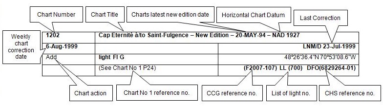
The last correction number is identified with the LNM/D or Last Notice to Mariners Number / Date.
Mariners are advised that only the most critical changes that directly affect safety to navigation are issued in “Section 2 – Chart Corrections.” This limitation is required to ensure that charts remain as clear and easy to read as possible. As a result, mariners may see minor discrepancies of a non-critical nature between information in official publications. For example, a small change in the nominal range or focal height of a light may not result in the production of a chart correction in Notices to Mariners, but may result in a correction in the List of Lights, Buoys and Fog Signals publication.
Note: In the case of a discrepancy between information provided on CHS charts relating to aids to navigation, and the List of Lights, Buoys and Fog Signals publication, the latter shall be deemed as containing the most up-to-date information.
Canadian Nautical Charts & Publications
A source list of Canadian nautical charts and publications is published in Notice No. 14 of the Notices to Mariners Annual Edition 2024. The source supply and the prices effective at the time of printing are listed. For current chart edition dates, please refer to the following website: www.chs-shc.gc.ca/charts-cartes/paper-papier/index-eng.asp
Explanatory Notes – Marine Communications and Traffic Services (MCTS)
Navigational Warnings / Notices to Shipping
The Canadian Coast Guard (CCG) is implementing a number of changes to the aids to navigation system in Canada.
These changes are advertised as Navigational Warnings, formerly called Notices to ShippingFootnote 1, that are broadcast by the CCG, and are then followed up with Notices to Mariners, then charts are updated by hand correction, reprints or new editions.
Mariners are advised that all relevant Navigational Warnings (NAVWARN) should be kept until superseded by Notices to Mariners or through revised charts issued by the Canadian Hydrographic Service (CHS).
NAVWARN are accessible on the applicable regional page on the CCG Navigational Warnings website at http://nis.ccg-gcc.gc.ca.
CHS is reviewing the impact of these changes with CCG and together are preparing an action plan on the issuing of chart revisions.
For further information, contact your regional NAVWARN Issuing Desk.
Atlantic Region (North)
* Port aux Basques MCTS Centre
“N” Series NAVWARN
Canadian Coast Guard
49 Stadium Rd.
P.O. Box 99
Port aux Basques, NL A0M 1C0
Telephone: 709-695-2168 or 1-800-563-9089
Facsimile: 709-695-7784
Email: NAVWARN.MCTSPortAuxBasques@innav.gc.ca
Central Region
* Prescott MCTS Centre
“Q” and “C” Series NAVWARN
Canadian Coast Guard
401 King Street West
P.O. Box 1000
Prescott, ON K0E 1T0
Telephone: 613-925-0666
Facsimile: 613-925-4519
Email: NAVWARN.MCTSPrescott@innav.gc.ca
Atlantic Region (South)
* Sydney MCTS Centre
“M” Series NAVWARN
Canadian Coast Guard
1190 Westmount Road
Sydney, NS B1R 2J6
Telephone: 902-564-7751 or 1-800-686-8676
Facsimile: 902-564-7662
Email: NAVWARN.MCTSSydney@innav.gc.ca
Arctic Region
* Iqaluit MCTS Centre
Operational from approximately mid-May until late December.
“A” Series NAVWARN
Canadian Coast Guard
P.O. Box 189
Iqaluit, NU X0A 0H0
Telephone: 867-979-5269
Facsimile: 867-979-4264
Email: NAVWARN.MCTSIqaluit@innav.gc.ca
* Service available in English and French.
Index
Numerical Index of Canadian Charts Affected
This numerical index lists all nautical charts mentioned in this monthly edition of Notices to Mariners. Only charts appearing in Section 2 of this publication require a chart correction. The appearance of charts in all other sections, particularly those related to the correction of other nautical publications, is included here for reference.
| 1201 | 2181 | 4279 | 5163 |
| 1202 | 2203 | 4374 | 5164 |
| 1226 | 2207 | 4375 | 5412 |
| 1230 | 2241 | 4381 | 5476 |
| 1233 | 2251 | 4405 | 5505 |
| 1313 | 2283 | 4416 | 5705 |
| 1314 | 2303 | 4432 | 5707 |
| 1316 | 2305 | 4452 | 6100 |
| 1317 | 2306 | 4459 | 6215 |
| 1429 | 2307 | 4466 | 6408 |
| 1430 | 2308 | 4467 | 6416 |
| 1434 | 2309 | 4523 | 6423 |
| 1435 | 2312 | 4642 | 7621 |
| 1509 | 2315 | 4682 | 7661 |
| 2017 | 3656 | 4823 | 7663 |
| 2042 | 4003 | 4849 | 7665 |
| 2064 | 4012 | 4856 | 8007 |
| 2067 | 4013 | 4906 | 14848 (U.S.) |
| 2077 | 4023 | 4940 | 14853 (U.S.) |
| 2085 | 4045 | 4971 | 14883 (U.S.) |
| 2121 | 4230 | 5003 | |
| 2123 | 4240 | 5135 |
SECTION 1 - GENERAL AND SAFETY INFORMATION
*505/23Canadian Hydrographic Service – Magnetic Declination Calculations
(Recurrent publication of notice *505/23, originally published in the Notices to Mariners – Monthly Eastern Edition 05/2023 publication.)
Mariners are advised that CHS has adopted the harmonized World Magnetic Model (WMM), as found on the NCEI/NOAA website. Old compass rose declination information on CHS navigational products can be updated using this website: https://www.ngdc.noaa.gov/geomag/calculators/magcalc.shtml#declination. While the differences in the model declinations are small each year, they can become more significant over a large period of time.
*1207/23Canadian Hydrographic Service – Inappropriate Geographical Names Review Process
(Recurrent publication of notice *1207/23, originally published in the Notices to Mariners – Monthly Eastern Edition 12/2023 publication.)
The records of the Canadian Hydrographic Service could contain geographical names that may be considered inappropriate, offensive and derogatory. Geographical naming authorities are in the process of addressing many offensive place names, the review process is underway. For more information, about inappropriate geographical names, please see the following announcement.
*301/24Canadian Hydrographic Service – Nautical Charts
|
Charts |
Main Title |
Scale |
Edition Date |
Published |
Cat# |
Price |
|
New Charts |
||||||
|
3656 |
Useless Inlet and Fatty Basin |
1:12 000 |
2024-02-09 |
2024-03-22 |
2 |
$20.00 |
*302/24Canadian Hydrographic Service – Electronic Navigational Charts
|
S-57 ENC Number |
Chart Title |
ENC Compilation Scale |
Published |
|
New Charts |
|||
|
CA29PJ6A (Edn 1.000) |
Western Foxe Basin |
1:175 000 |
2024-03-29 |
|
CA29PKDA (Edn 1.000) |
Eastern Foxe Basin |
1:175 000 |
2024-03-22 |
|
CA45RS2B (Edn 1.000) |
CA45RS2B |
1:90 000 |
2024-03-22 |
|
CA45RSCA (Edn 1.000) |
CA45RSCA |
1:90 000 |
2024-03-22 |
|
CA45RSNA (Edn 1.000) |
CA45RSNA |
1:90 000 |
2024-03-22 |
|
CA45RSYA (Edn 1.000) |
CA45RSYA |
1:90 000 |
2024-03-22 |
|
CA462SCA (Edn 1.000) |
CA462SCA |
1:22 500 |
2024-03-22 |
|
CA462SNA (Edn 1.000) |
CA462SNA |
1:22 500 |
2024-03-22 |
|
CA462SNB (Edn 1.000) |
CA462SNB |
1:22 500 |
2024-03-22 |
|
CA46CR5A (Edn 1.000) |
CA46CR5A |
1:45 000 |
2024-03-22 |
|
CA46CRFA (Edn 1.000) |
CA46CRFA |
1:45 000 |
2024-03-22 |
|
CA46CRRA (Edn 1.000) |
CA46CRRA |
1:45 000 |
2024-03-22 |
|
CA46CS2A (Edn 1.000) |
CA46CS2A |
1:45 000 |
2024-03-22 |
|
CA46CSCA (Edn 1.000) |
CA46CSCA |
1:45 000 |
2024-03-22 |
|
CA46CSNA (Edn 1.000) |
CA46CSNA |
1:45 000 |
2024-03-22 |
|
CA46NRFA (Edn 1.000) |
CA46NRFA |
1:45 000 |
2024-03-22 |
|
CA46NRRA (Edn 1.000) |
CA46NRRA |
1:45 000 |
2024-03-22 |
|
CA46NS2A (Edn 1.000) |
CA46NS2A |
1:45 000 |
2024-03-22 |
|
CA46NS2B (Edn 1.000) |
CA46NS2B |
1:45 000 |
2024-03-22 |
|
CA46NSCA (Edn 1.000) |
CA46NSCA |
1:45 000 |
2024-03-22 |
|
CA46YQUA (Edn 1.000) |
CA46YQUA |
1:45 000 |
2024-03-22 |
|
CA46YR5A (Edn 1.000) |
CA46YR5A |
1:45 000 |
2024-03-22 |
|
CA46YR5B (Edn 1.000) |
CA46YR5B |
1:45 000 |
2024-03-22 |
|
CA46YRFA (Edn 1.000) |
CA46YRFA |
1:45 000 |
2024-03-22 |
|
CA46YRFB (Edn 1.000) |
CA46YRFB |
1:45 000 |
2024-03-22 |
|
CA46YRRA (Edn 1.000) |
CA46YRRA |
1:45 000 |
2024-03-22 |
|
CA46YS2A (Edn 1.000) |
CA46YS2A |
1:45 000 |
2024-03-22 |
|
CA471211 (Edn 1.000) |
CA471211 |
1:45 000 |
2024-03-22 |
|
CA471212 (Edn 1.000) |
CA471212 |
1:22 500 |
2024-03-22 |
|
CA471213 (Edn 1.000) |
CA471213 |
1:45 000 |
2024-03-22 |
|
CA471215 (Edn 1.000) |
CA471215 |
1:22 500 |
2024-03-22 |
|
CA471216 (Edn 1.000) |
CA471216 |
1:45 000 |
2024-03-22 |
|
CA471221 (Edn 1.000) |
CA471221 |
1:22 500 |
2024-03-22 |
|
CA471223 (Edn 1.000) |
CA471223 |
1:22 500 |
2024-03-22 |
|
CA479QJA (Edn 1.000) |
CA479QJA |
1:22 500 |
2024-03-22 |
|
CA479QUA (Edn 1.000) |
CA479QUA |
1:45 000 |
2024-03-22 |
|
CA479QUB (Edn 1.000) |
CA479QUB |
1:45 000 |
2024-03-22 |
|
CA479R5A (Edn 1.000) |
CA479R5A |
1:45 000 |
2024-03-22 |
|
CA479RFA (Edn 1.000) |
CA479RFA |
1:45 000 |
2024-03-22 |
|
CA47KQJA (Edn 1.000) |
CA47KQJA |
1:90 000 |
2024-03-22 |
|
CA47KQJB (Edn 1.000) |
CA47KQJB |
1:90 000 |
2024-03-22 |
|
CA47KQUA (Edn 1.000) |
CA47KQUA |
1:90 000 |
2024-03-22 |
|
CA47KR5A (Edn 1.000) |
CA47KR5A |
1:90 000 |
2024-03-22 |
|
CA47VQ8A (Edn 1.000) |
CA47VQ8A |
1:90 000 |
2024-03-22 |
|
CA47VQJA (Edn 1.000) |
CA47VQJA |
1:90 000 |
2024-03-22 |
|
CA47VQUA (Edn 1.000) |
CA47VQUA |
1:90 000 |
2024-03-22 |
|
CA486Q8A (Edn 1.000) |
CA486Q8A |
1:22 500 |
2024-03-22 |
|
CA486Q8B (Edn 1.000) |
CA486Q8B |
1:22 500 |
2024-03-22 |
|
CA486QJA (Edn 1.000) |
CA486QJA |
1:90 000 |
2024-03-22 |
|
CA4B755A (Edn 1.000) |
CA4B755A |
1:90 000 |
2024-03-29 |
|
CA4B75FA (Edn 1.000) |
CA4B75FA |
1:90 000 |
2024-03-29 |
|
CA4B75RA (Edn 1.000) |
CA4B75RA_6900N12500W |
1:90 000 |
2024-03-29 |
|
CA4B762A (Edn 1.000) |
CA4B762A |
1:90 000 |
2024-03-29 |
|
CA55USRA (Edn 1.000) |
CA55USRA |
1:6 000 |
2024-03-29 |
|
CA566SQA (Edn 1.000) |
CA566SQA |
1:11 000 |
2024-03-15 |
|
CA566SRA (Edn 1.000) |
CA566SRA |
1:11 000 |
2024-03-15 |
|
CA567SJA (Edn 1.000) |
CA567SJA |
1:11 000 |
2024-03-15 |
|
CA567SKA (Edn 1.000) |
CA567SKA |
1:11 000 |
2024-03-15 |
|
CA567SLA (Edn 1.000) |
CA567SLA |
1:11 000 |
2024-03-15 |
|
CA571057 (Edn 1.000) |
CA571057 |
1:6 000 |
2024-03-01 |
|
CA571251 (Edn 1.000) |
CA571251 |
1:11 000 |
2024-03-22 |
|
CA571252 (Edn 1.000) |
CA571252 |
1:11 000 |
2024-03-22 |
|
CA571253 (Edn 1.000) |
CA571253 |
1:11 000 |
2024-03-22 |
|
CA597L1A (Edn 1.000) |
CA597L1A |
1:11 000 |
2024-03-29 |
|
New Editions |
|||
|
CA262Q8A (Edn 2.000) |
CA262Q8A |
1:1 750 000 |
2024-03-01 |
|
CA279Q8A (Edn 2.000) |
CA279Q8A |
1:1 750 000 |
2024-03-29 |
|
CA279Q8B (Edn 2.000) |
CA279Q8B |
1:175 000 |
2024-03-01 |
|
CA279Q8B (Edn 3.000) |
CA279Q8B |
1:175 000 |
2024-03-29 |
|
CA370381 (Edn 8.000) |
Strait of Georgia, Central Portion/Partie Centrale (Part 1 of 2) |
1:40 000 |
2024-03-22 |
|
CA376062 (Edn 13.000) |
West Point à/to Baie de Tracadie |
1:50 000 |
2024-03-15 |
|
CA376109 (Edn 9.000) |
Country Island to/à Barren Island |
1:30 000 |
2024-03-01 |
|
CA376660 (Edn 3.000) |
Cape St. John to/à St. Anthony |
1:75 000 |
2024-03-22 |
|
CA376689 (Edn 3.000) |
North Head to/à Murphy Head |
1:50 000 |
2024-03-22 |
|
CA45FRFA (Edn 2.000) |
Transit5000N06000W |
1:22 500 |
2024-03-01 |
|
CA470095 (Edn 8.000) |
Jervis Inlet |
1:25 000 |
2024-03-22 |
|
CA470756 (Edn 4.000) |
Halibut Bank to/à Ballenas Channel |
1:15 000 |
2024-03-22 |
|
CA471014 (Edn 3.000) |
Hippa Island, Seal Inlet, Tartu Inlet, Masset Inlet |
1:180 000 |
2024-03-01 |
|
CA471020 (Edn 4.000) |
Selwyn Inlet |
1:45 000 |
2024-03-29 |
|
CA471021 (Edn 5.000) |
Atli Inlet |
1:180 000 |
2024-03-29 |
|
CA476547 (Edn 5.000) |
Grand Harbour |
1:12 500 |
2024-03-15 |
|
CA476673 (Edn 5.000) |
Cape Daly to/à Amiktok Island |
1:20 000 |
2024-03-22 |
|
CA476674 (Edn 4.000) |
Amiktok Island to Osborne Point |
1:20 000 |
2024-03-22 |
|
CA476681 (Edn 3.000) |
Osborne Point to Cape Kakkiviak |
1:20 000 |
2024-03-22 |
|
CA543M8A (Edn 2.000) |
Port4550N07390W |
1:6 000 |
2024-03-01 |
|
CA54AQGA (Edn 2.000) |
Charlottetown Harbour North |
1:0 |
2024-03-29 |
|
CA55VSAA (Edn 2.000) |
Port5140N05720W |
1:6 000 |
2024-03-22 |
|
CA570123 (Edn 10.000) |
Vancouver Harbour Central Portion/Partie Centrale |
1:6 000 |
2024-03-08 |
|
CA570626 (Edn 4.000) |
Kitimat Harbour |
1:7 500 |
2024-03-29 |
|
Charts Permanently Withdrawn |
|||
|
CA370145 |
Strait of Georgia, Southern Portion/Partie Sud |
Cancelled by CA471221,CA471216,CA471213,CA471212 |
|
|
CA370367 |
Juan de Fuca Strait to/à Strait of Georgia (Western Portion, Part 1 of 2) |
Cancelled by CA471223,CA471221 |
|
|
CA370368 |
Juan de Fuca Strait to/à Strait of Georgia (Eastern Portion, Part 2 of 2) |
|
|
|
CA370382 |
Strait of Georgia, Central Portion/Partie Centrale (Part 2 of 2) |
Cancelled by CA471215,CA471213,CA471212,CA471211 |
|
|
CA376049 |
Nunasuk Island to Calf Cow and Bull Islands |
|
|
|
CA376050 |
Seniartlit Islands to Nain |
|
|
|
CA376094 |
Strait of Belle Isle |
Cancelled by CA45RSNA |
|
|
CA376351 |
Dog Islands to/à Cape Makkovik |
|
|
|
CA376352 |
Makkovik Bay (Continuation A) |
|
|
|
CA376355 |
Approaches to Cartwright, Black Island to Tumbledown Dick Island |
|
|
|
CA376356 |
Quaker Hat to/à Cape Harrison |
|
|
|
CA376358 |
Green Bay to/à Double Island |
|
|
|
CA376361 |
Cape Makkovik to/à Winsor Harbour Island |
|
|
|
CA376362 |
Kaipokok Bay |
|
|
|
CA376363 |
Cut Throat Island to/à Quaker Hat |
|
|
|
CA376368 |
Cape Harrigan to/aux Kitlit Islands |
|
|
|
CA376370 |
Cape Harrison to Dog Islands |
|
|
|
CA376429 |
Corbett Island to Ship Harbour Head |
|
|
|
CA376483 |
Davis Inlet to/aux Seniarlit Islands |
|
|
|
CA376596 |
Domino Point to Cape North |
|
|
|
CA376597 |
Table Harbour, Continuation at same scale |
Cancelled by CA46CSCA |
|
|
CA376650 |
Cape Kiglapait to Khikkertarsoak North Island |
|
|
|
CA376665 |
Hare Islands to/à North Head |
|
|
|
CA376668 |
Khikkertarsoak North Island to/à Morhardt Point |
|
|
|
CA376669 |
Khikkertarsoak North Island To Morhardt Point , Continuation A |
|
|
|
CA376738 |
Lake Melville |
|
|
|
CA376739 |
Epinette Point to/à Terrington Basin |
|
|
|
CA376811 |
South Auliatsivik Island to/à Fenstone Tickle Island |
|
|
|
CA376820 |
Approaches to Hamilton Inlet |
|
|
|
CA376822 |
Winsor Harbour Island to/aux Kikkertaksoak Islands |
|
|
|
CA376823 |
Winsor Harbour Island to/aux Kikkertaksoak Islands |
|
|
|
CA470003 |
Haro Strait, Boundary Pass and/et Satellite Channel |
Cancelled by CA471223,CA471221 |
|
|
CA470004 |
Howe Sound |
Cancelled by CA471215,CA471213,CA471212,CA471211 |
|
|
CA470005 |
North Pender Island to/à Thetis Island |
Cancelled by CA471221,CA471213 |
|
|
CA470070 |
Thetis Island to/à Nanaimo |
Cancelled by CA471221,CA471213,CA471212 |
|
|
CA470075 |
Race Rocks to/à D'Arcy Island |
Cancelled by CA471223 |
|
|
CA470194 |
Indian Arm - Continuation A |
Cancelled by CA471216 |
|
|
CA470411 |
Welcome Passage |
Cancelled by CA571253,CA571252,CA571251 |
|
|
CA476360 |
Niger Sound |
Cancelled by CA462SNB |
|
|
CA476366 |
Ice Tickle and/et Indian Harbour |
Cancelled by CA46NS2B |
|
|
CA476369 |
Windy Tickle |
|
|
|
CA476380 |
St. Lewis Sound and/et Inlet |
|
|
|
CA476485 |
South of / Sud de Drawbucket Tickle |
Cancelled by CA479R5A |
|
|
CA476494 |
Sandwich Bay |
|
|
|
CA476495 |
Continuation A - Sandwich Bay |
Cancelled by CA46CS2A |
|
|
CA476568 |
Savage Cove to/à St. Barbe Bay |
|
|
|
CA476600 |
Akuliakatak Peninsula to Satosoak Island |
|
|
|
CA476630 |
Hawke Bay and / et Deer Pass (Squasho Run) |
|
|
|
CA476631 |
Head of Hawke Bay |
|
|
|
CA476634 |
Approaches to/à White Bear Arm |
|
|
|
CA476635 |
Occasional Harbour |
Cancelled by CA462SNA |
|
|
CA476734 |
Groswater Bay |
|
|
|
CA476735 |
Ticoralak Island to/à Green Island |
|
|
*303/24Transport Canada - Ship Safety Bulletins #06, #07 and #08/2024
New Ship Safety Bulletins have recently been
posted on the
Transport Canada website.
To view or download these bulletins, please click on the
links below:
SSB#06/2024 – Maintaining fire
safety systems and
equipment
RDIMS#
19958872
SSB#07/2024 – Irish seafarers
can now seek Canadian recognition of their STCW
certificates
RDIMS#
20127556
SSB#08/2024 – Requirements for
the use of an Electronic Record Books
System
RDIMS#
20045967
Sign up for e-Bulletin to receive an e-mail notice each time a new Ship Safety Bulletin is published on our website.
Contact us at marinesafety-securitemaritime@tc.gc.ca or 1-855-859-3123 (Toll Free).
*305/24Summerside Harbour and Approaches / et les approches – Unlit Buoy Aid Designator Changed
Reference chart: 4459
The designator of the following unlit buoy has been permanently changed from “DG1” to “DF1”:
|
Aid Name |
LL # |
Position |
|
Summerside Harbour buoy DF1 |
6020.6 |
46° 23’ 16.2”N 063° 47’ 30.7”W |
(G2024-045)
Section 1A: Temporary and Preliminary Notices
Reminder – Comment Period for Active Preliminary Notices
This is a reminder that the comment period is still open for the following active Preliminary notices:
|
Notice # |
Reference Chart # |
Aids Affected |
Intent of Notice |
|
Atlantic Coast |
|||
|
4940 |
List |
Notice of Proposed Changes |
|
|
Inland Waters |
|||
|
5412 |
2553 |
Aid to Navigation to be Discontinued |
|
|
7661 |
List |
Aids to Navigation to be Discontinued |
|
Please refer to the Notices to Mariners - Monthly Summary of Temporary and Preliminary Notices publication for details.
Newfoundland and Labrador Coast
Temporary Notices
*306(T)/24Larkin Point to / à Cape Anguille – Marine Works: Wharf Construction
Reference chart: 4682
Wharf demolition and breakwater reconstruction operations underway in Codroy, NL at the following coordinates:
|
47° 52’ 50.0”N 59° 23’ 49.0”W |
|
47° 52’ 46.0”N 59° 23’ 52.0”W |
|
47° 52’ 53.0”N 59° 24’ 11.0”W |
Caution.
(NW-N-0161-24)
Preliminary Notices
Atlantic Region
|
Comment
Submission |
Comments should be directed to the following: |
*307(P)/24Little Bay Arm and Approaches / et les approaches – Light Buoys to be Discontinued
Reference chart: 4523
The Canadian Coast Guard proposes to permanently discontinue the following aids to navigation:
|
Aid Name |
LL # |
Position |
|
Otter Island Shoal light buoy DB2 |
336.21 |
49° 36’ 38.9”N 055° 53’ 50.8”W |
|
Little Bay Arm light buoy DB3 |
336.25 |
49° 36’ 10.4”N 055° 54’ 34.3”W |
|
Otter Island Narrows light buoy DB4 |
336.26 |
49° 36’ 11.9”N 055° 54’ 36.3”W |
|
Little Arm Bay light buoy DB5 |
336.27 |
49° 35’ 29.9”N 055° 55’ 45.8”W |
Initial publication date: Friday, March 29, 2024
Comment submission
deadline: Thursday, June 27, 2024
(N2024-013)
*308(P)/24Great St. Lawrence Harbour and / et Lamaline Harbour – Light Buoys to be Discontinued
Reference chart: 4642
The Canadian Coast Guard proposes to permanently discontinue the following aids to navigation:
|
Aid Name |
LL # |
Position |
|
Sally Rock light buoy PAG3 |
75.53 |
46° 50’ 56.8”N 055° 44’ 23.2”W |
|
East Sunker light buoy PAG1 |
75.54 |
46° 50’ 28.4”N 055° 44’ 35.1”W |
Initial publication date: Friday, March 29, 2024
Comment submission
deadline: Thursday, June 27, 2024
(N2024-008)
Atlantic Coast
Temporary Notices
*309(T)/24Mouillages et Installations Portuaires/Anchorages and Harbour Installations - Haute Côte-Nord – Obstruction: Anchors
Reference chart: 1226
Lost anchors at the following coordinates:
|
49° 59’ 53.4”N 66° 48’ 45.0”W |
|
50° 00’ 04.3”N 66° 48’ 38.4”W |
|
50° 00’ 55.2”N 66° 46’ 06.0”W |
(NW-Q-0166-20, 0580-23, 0870-23)
*310(T)/24Mouillages et Installations Portuaires/Anchorages and Harbour Installations - Haute Côte-Nord – Marine Works: Wharf Construction
Reference chart: 1226
Wharf repair works are taking place daily between 1100 UTC
and 2100 UTC at wharves 1, 2 and 3 of the Port-Cartier
Harbour.
Barge and safety boat on site.
(NW-C-0316-24)
Preliminary Notices
No notices applicable for this edition.
Inland Waters
Temporary Notices
*311(T)/24Canal de la Rive Sud – Marine Works: Bridge Demolition
Reference chart: 1429
Demolition operations taking place at the bypass bridge of Île
des Sœurs from Monday to Thursday between 1000 UTC and 2100
UTC. Navigation channel is marked and reduced with a minimum
width of 10 metres.
Two barges are on site.
(NW-C-0297-24)
*312(T)/24Lac Saint-Louis – Marine Works: Construction
Reference chart: 1430
Suspended platforms have been installed under the Île aux
Tourtes bridge. The bridge clearance is reduced by 4 metres.
Barges are on site.
The platforms will remain in place until September 2024.
(NW-Q-1715-23)
*313(T)/24Havres et Mouillages - Harbours and Anchorages - Côte-Nord/North Shore – Waterway Information: Reduction of Capacity at Mooring Bollards
Reference chart: 4452
Capacity reduced to 10 metric tons for bollards B01, B10, B12, B14 and B17 and 20 metric tons for bollards B03 to B09, B11, B13, B15, B16 and B18 at Natashquan public wharf. Bollard B02 is still out of order.
(NW-C-0292-24)
*314/24Hamilton Harbour – Silting Dredged
Reference: Notice 1218(T)/16 is cancelled (Chart 2067).
Silting reported along the north faces of piers 11 and 12 has been dredged.
*315/24Lake Ontario/Lac Ontario (Western Portion/Partie Ouest) – Silting Dredged
Reference: Notice 1011(T)/16 is cancelled (Chart 2077).
Silting reported in the main entrance channel to Fifty Point Marina has been dredged.
Preliminary Notices
Arctic Region
|
Comment
Submission |
Comments should be directed to the following:
Superintendent, |
*316(P)/24Demarcation Bay to/à Philips Bay – Aid to Navigation to be Discontinued
Reference chart: 7661
The Canadian Coast Guard proposes to permanently discontinue the following aid to navigation:
|
Aid Name |
LL # |
Position |
|
Shingle Point |
4618 |
69° 00’ 29.4”N 137° 34’ 21.7”W |
Initial publication date: Friday, March 29, 2024
Comment submission
deadline: Thursday, June 27, 2024
(A2024-004)
SECTION 2 - CHART CORRECTIONS
1230 - Mont-Louis - New Edition - 19-FEB-2010 - NAD 1983
(See Chart 1, K41)
(See Chart 1, I10)
(See Chart 1, I10)
1313 - Batiscan au/to Lac Saint-Pierre - New Edition - 08-MAR-2019 - NAD 1983
(See Chart 1, N62.1)
4003 - Cape Breton to / à Cape Cod - New Edition - 21-MAR-2003 - NAD 1983
(See Chart 1, L25)
4012 - Yarmouth to / à Halifax - New Edition - 14-FEB-2003 - NAD 1983
(See Chart 1, L25)
4013 - Halifax to / à Sydney - New Edition - 06-SEP-2002 - NAD 1983
(See Chart 1, L25)
(See Chart 1, L25)
4023 - Northumberland Strait / Détroit de Northumberland - New Edition - 27-DEC-2002 - World Geodetic System 1984
4045 - Sable Island Bank / Banc de I'Île de Sable to / au St. Pierre Bank / Banc de Saint-Pierre - New Edition - 10-OCT-2003 - NAD 1983
(See Chart 1, L25)
(See Chart 1, L25)
4230 - Little Hope Island to / à Cape St Marys - New Chart - 15-JUN-1990 - NAD 1983
(See Chart 1, I10)
4240 - Liverpool Harbour to / à Lockeport Harbour - New Chart - 06-OCT-1989 - NAD 1983
(See Chart 1, I10)
(See Chart 1, I10)
(See Chart 1, I10)
(See Chart 1, I10)
(See Chart 1, I10)
(See Chart 1, I10)
(See Chart 1, I10)
(See Chart 1, I10)
(See Chart 1, I10)
(See Chart 1, I10)
(See Chart 1, I10)
(See Chart 1, I10)
(See Chart 1, I10)
(See Chart 1, I10)
(See Chart 1, I10)
(See Chart 1, I10)
(See Chart 1, I10)
(See Chart 1, I10)
(See Chart 1, I10)
(See Chart 1, I10)
(See Chart 1, I10)
(See Chart 1, I10)
(See Chart 1, I10)
(See Chart 1, I10)
(See Chart 1, I10)
(See Chart 1, I10)
(See Chart 1, I10)
(See Chart 1, I10)
(See Chart 1, I10)
(See Chart 1, I10)
(See Chart 1, I10)
(See Chart 1, I10)
(See Chart 1, I10)
(See Chart 1, I10)
(See Chart 1, I10)
(See Chart 1, I10)
(See Chart 1, I10)
(See Chart 1, I10)
(See Chart 1, I10)
(See Chart 1, I10)
(See Chart 1, I10)
(See Chart 1, I10)
(See Chart 1, I10)
(See Chart 1, I10)
(See Chart 1, I10)
(See Chart 1, I10)
(See Chart 1, I10)
(See Chart 1, I10)
(See Chart 1, I10)
(See Chart 1, I10)
(See Chart 1, I10)
(See Chart 1, I10)
(See Chart 1, I10)
(See Chart 1, I10)
(See Chart 1, I10)
(See Chart 1, I10)
(See Chart 1, I10)
(See Chart 1, I10)
(See Chart 1, I10)
(See Chart 1, I10)
(See Chart 1, I10)
(See Chart 1, I10)
(See Chart 1, I10)
(See Chart 1, I10)
(See Chart 1, I10)
(See Chart 1, I10)
(See Chart 1, I10)
(See Chart 1, I10)
4375 - Guyon Island to / à Flint Island - New Edition - 11-OCT-2002 - NAD 1983
(See Chart 1, L25)
4381 - Deep Cove - New Edition - 28-APR-2023 - World Geodetic System 1984
(See Chart 1, Qb)
(See Chart 1, Qb)
to 44°32′06.8″N 064°06′53.9″W
4381 - Mahone Bay - New Edition - 28-APR-2023 - World Geodetic System 1984
(See Chart 1, Qb)
4405 - Pictou Island to / aux Tryon Shoals - New Edition - 21-FEB-2003 - NAD 1983
(See Chart 1, N30)
4432 - Havre de Mingan - New Edition - 01-AUG-2022 - NAD 1983
(See Chart 1, I10)
(See Chart 1, I10)
4466 - Hillsborough Bay - New Edition - 21-MAR-2003 - NAD 1983
(See Chart 1, N30)
4467 - Rustico Bay - New Edition - 27-JAN-2023 - NAD 1983
(See Chart 1, P16)
4823 - Cape Ray to / à Garia Bay - New Chart - 16-JAN-2004 - NAD 1983
(See Chart 1, L25)
(See Chart 1, L25)
4849 - The Admiral's Marina - New Chart - 30-DEC-1988 - NAD 1983
(See Chart 1, P1)
(See Chart 1, P1)
(See Chart 1, P16)
(See Chart 1, P16)
(See Chart 1, P16)
4856 - Bonavista Bay: Western Portion / Partie ouest - New Chart - 13-OCT-2000 - NAD 1983
(See Chart 1, P16)
4906 - West Point à / to Baie de Tracadie - New Chart - 18-MAR-1988 - NAD 1983
(See Chart 1, I10)
4971 - Blanc Sablon à/to Baie de Bonne-Espérance - New Chart - 10-NOV-2017 - NAD 1983
(See Chart 1, F4.1)
51°25′03.5″N 057°08′57.2″W
and 51°25′04.8″N 057°09′08.5″W
(See Chart 1, F32)
(See Chart 1, F33)
4971 - Blanc-Sablon - New Chart - 10-NOV-2017 - NAD 1983
Download Patch - https://www.notmar.gc.ca/chsftp/patches/4971_6410866_6_202402140944.pdf
4971 - Quai/Wharf Blanc-Sablon - New Chart - 10-NOV-2017 - NAD 1983
Download Patch - https://www.notmar.gc.ca/chsftp/patches/4971_6410866_5_202402140944.pdf
5003 - Hudson Bay (Southern Portion) and James Bay - New Edition - 29-MAY-2015 - Unknown
(See Chart 1, I10)
(See Chart 1, I10)
(See Chart 1, I10)
(See Chart 1, I10)
(See Chart 1, I10)
(See Chart 1, I10)
(See Chart 1, I10)
(See Chart 1, I10)
(See Chart 1, I10)
(See Chart 1, I10)
(See Chart 1, I10)
(See Chart 1, I10)
(See Chart 1, I10)
5163 - Cul de Sac - New Chart - 30-MAR-2018 - NAD 1983
(See Chart 1, P16)
5163 - RIGOLET - NEW CHART - 30-MAR-2018 - NAD 1983
(See Chart 1, P16)
(See Chart 1, P16)
5163 - Ticorolak Head to/à Green Island - New Chart - 30-MAR-2018 - NAD 1983
(See Chart 1, P16)
(See Chart 1, P16)
(See Chart 1, P16)
(See Chart 1, P16)
(See Chart 1, P16)
5164 - Lake Melville - New Chart - 27-MAR-2020 - NAD 1983
(See Chart 1, P16)
5476 - Kuujjuarapik - New Edition - 27-MAY-2005 - Unknown
(See Chart 1, I10)
(See Chart 1, I10)
(See Chart 1, I10)
(See Chart 1, I10)
5505 - Bélanger Island à/to Cotter Island - New Edition - 04-AUG-2017 - World Geodetic System 1984
(See Chart 1, I10)
(See Chart 1, I10)
(See Chart 1, I10)
(See Chart 1, I10)
(See Chart 1, I10)
(See Chart 1, I10)
(See Chart 1, I10)
(See Chart 1, I10)
(See Chart 1, I10)
(See Chart 1, I10)
(See Chart 1, I10)
5705 - Cape Dufferin to/à Broughton Island - New Edition - 13-MAY-1983 - Unknown
(See Chart 1, I10)
(See Chart 1, I10)
(See Chart 1, I10)
(See Chart 1, I10)
(See Chart 1, I10)
(See Chart 1, I10)
(See Chart 1, I10)
(See Chart 1, I10)
(See Chart 1, I10)
(See Chart 1, I10)
5707 - Bélanger Island to/à Long Island - New Edition - 28-JAN-1983 - NAD 1927
(See Chart 1, I10)
(See Chart 1, I10)
(See Chart 1, I10)
(See Chart 1, I10)
(See Chart 1, I10)
(See Chart 1, I10)
(See Chart 1, I10)
(See Chart 1, I10)
(See Chart 1, I10)
(See Chart 1, I10)
(See Chart 1, I10)
(See Chart 1, I10)
(See Chart 1, I10)
6408 - Cache Island to/à Rabbitskin River Kilometre 233 / Kilomètre 301 - New Edition - 31-DEC-2010 - NAD 1983
(See Chart 1, I10)
6423 - Askew Islands to/à Bryan Island Kilometre 1180 / Kilometre 1240 - New Edition - 11-MAR-2022 - World Geodetic System 1984
(See Chart 1, I10)
(See Chart 1, I10)
(See Chart 1, Qb)
to 66°51′49.9″N 130°07′58.3″W
(See Chart 1, Qb)
to 66°52′15.9″N 130°07′27.6″W
(See Chart 1, Qp)
to 66°52′47.0″N 130°07′05.7″W
(See Chart 1, Qc)
to 66°59′03.9″N 130°14′43.2″W
(See Chart 1, Qc)
(See Chart 1, Qc)
(See Chart 1, Qb)
(See Chart 1, Qc)
(See Chart 1, Qb)
(See Chart 1, Qb)
to 67°00′08.1″N 130°12′36.3″W
7621 - Amundsen Gulf - New Edition - 25-FEB-2022 - NAD 1983
(See Chart 1, K12)
(See Chart 1, I10)
(See Chart 1, I10)
7665 - Franklin Bay and/et Darnley Bay - New Chart - 13-JUN-1986 - NAD 1927
(See Chart 1, K12)
(See Chart 1, I10)
(See Chart 1, I10)
8007 - Halifax to / à Sable Island / Île de Sable, Including / y compris Emerald Bank / Banc d'Émeraude and / et Sable Island Bank / Banc de l'Île de Sable - New Edition - 30-AUG-2002 - NAD 1983
(See Chart 1, L25)
SECTION 3 - RADIO AIDS TO MARINE NAVIGATION CORRECTIONS
*317/24Radio Aids to Marine Navigation 2024 (Atlantic, St. Lawrence, Great Lakes, Lake Winnipeg, Arctic and Pacific)
Page 2-33
DELETE AS FOLLOWS:
Table 2-17 - Prince Rupert MCTS/VAJ - Ship/Shore Communications
|
Sites located at |
Channels |
Frequencies |
Remarks |
|
|
Transmit |
Receive |
|||
|
Dundas Island
54°31'16"N |
Ch16 |
- |
- |
|
|
Kitimat
54°03'20"N |
Ch11 |
- |
- |
|
|
Maitland Island
53°44’05”N |
Ch11 |
- |
- |
|
|
Porcher Island
53°55’04”N |
Ch11 |
- |
- |
|
|
… |
… |
… |
… |
… |
Page 2-38
DELETE AS FOLLOWS:
Table 2-18 - Prince Rupert MCTS/VAJ - Broadcasts
|
Time PST |
Site |
Frequency or Channel |
Contents |
|---|---|---|---|
|
… |
… |
… |
… |
|
Continuous |
Mount Hays
Mount Dent |
Ch21B (2021) |
Radiotelephony
•Technical
marine synopsis, marine forecast and marine extended
forecast for marine forecast areas 2, 3, 4, 5, 13, 14,
15, 16, 17. •All navigational warnings. |
|
Klemtu |
WX1 |
||
|
Barry Inlet |
WX2 |
||
|
Cumshewa |
WX3 |
||
|
Continuous |
Mount Ozzard
Esperanza |
C21B (2021) |
Radiotelephony
•Technical
marine synopsis, marine forecast and marine extended
forecast for marine forecast areas 1, 5, 6, 7, 8, 13,
14. •All navigational warnings. |
|
Eliza Dome |
WX1 |
||
|
Port Alberni |
WX2 |
||
|
Estevan Point |
WX3 |
* Kitimat site to be permanently
relocated to Maitland Island in 2021. Kitimat CMB on standby and
not transmitting while Maitland Island undergoes operational
testing.
** Maitland Island site in operational
test mode.
Page 2-51
DELETE AS FOLLOWS:
Table 2-25 - Victoria MCTS/VAK - Ship/Shore Communications
|
Sites located at |
Channels |
Frequencies |
Remarks |
|
|
Transmit |
Receive |
|||
|
… |
… |
… |
… |
… |
|
Discovery Mountain |
Ch16 |
- |
- |
- |
|
|
|
|
- |
- |
|
Port Hardy |
Ch16 |
- |
- |
- |
|
… |
… |
… |
… |
… |
Pages 2-51 to 2-53
DELETE AS FOLLOWS:
Table 2-26 - Victoria MCTS/VAK - Broadcasts
|
Time PST |
Site |
Frequency or Channel |
Contents |
|
07:10 |
Mount Parke |
Ch21B (2021) |
Radiotelephony •All navigational warnings. •Notices to Fish Harvesters. |
|
Watts Point |
WX1 |
||
|
Bowen Island |
WX3 |
||
|
07:20 |
Texada Island |
WX1 |
Radiotelephony •All navigational warnings. •Notices to Fish Harvesters. |
|
Port Hardy |
WX3 |
||
|
Discovery Mountain |
Ch21B (2021) |
||
|
13:10 |
Mount Parke |
Ch21B (2021) |
Radiotelephony •All navigational warnings. •Notices to Fish Harvesters. |
|
Watts Point |
WX1 |
||
|
Bowen Island |
WX3 |
||
|
13:20 |
Texada Island |
WX1 |
Radiotelephony •All navigational warnings. •Notices to Fish Harvesters. |
|
Port Hardy |
WX3 |
||
|
Discovery Mountain |
Ch21B (2021) |
||
|
20:20 |
Texada Island |
WX1 |
Radiotelephony •All navigational warnings. •Notices to Fish Harvesters. |
|
Port Hardy |
WX3 |
||
|
Discovery Mountain |
Ch21B (2021) |
||
|
21:10 |
Mount Parke |
Ch21B (2021) |
Radiotelephony •All navigational warnings. •Notices to Fish Harvesters. |
|
Watts Point |
WX1 |
||
|
Bowen Island |
WX3 |
||
|
Continuous |
Mount Parke |
Ch21B (2021) |
Radiotelephony •Technical marine synopsis and marine forecast for marine forecast areas 8, 9, 10, 11.
•Extended
forecast for marine forecast areas 7, 8, 9, 10,
11. •Fraser River Salmon Fishery Information. |
|
Watts Point |
WX1 |
||
|
Bowen Island |
WX3 |
||
|
Continuous |
Mount Helmcken |
WX3 |
Radiotelephony •Navigational warnings.
•Technical
marine synopsis, marine forecast and extended marine
forecast for marine forecast areas 7, 8, 9, 10,
11. •Automated Weather Reports for Juan de Fuca Strait: Cape Flattery, “JA” Buoy, Hein Bank, Smith Island, Ogden Point. |
|
Continuous |
|
|
Radiotelephony •Navigational warnings
•Technical
marine synopsis marine forecast and extended marine
forecast for marine forecast areas 5, 6, 11, 12, 13,
14. •Lighthouse Weather Reports: McInnes Island, Addenbroke Island, Egg Island, Pine Island, Scarlett Point, Pulteney Point, Chatham Point, Cape Scott, Quatsino. |
|
Port Hardy |
WX3 |
||
|
Continuous |
Texada Island |
WX1 |
Radiotelephony
•Navigational
warnings •Local and Lighthouse Weather Reports: Chatham Point, Cape Mudge, Cape Lazo, Chrome Island, Merry Island, Entrance Island. |
Page 2-73
AMEND AS FOLLOWS:
Table 2-41 - Radar Beacons Located in Northwest Territories
|
Name and Location |
Identifier |
Remarks |
|
… |
… |
… |
|
Pitt Island
69°09'15"N |
─ • ─ |
Navigation season only. |
|
Pullen Island
69°46' |
─ ─ • |
Navigation season only. |
|
Baillie Islands
70°37'38.7"N |
─ • ─ |
Navigation season only. |
|
… |
… |
… |
SECTION 4 - CANADIAN SAILING DIRECTIONS CORRECTIONS
The following Canadian Sailing Directions volumes have recently been updated on the Canadian Hydrographic Service website.
|
No. |
Title |
|
Atlantic Coast |
|
|
ATL104 |
Cape North to Cape Canso (including Bras d’Or Lake) |
|
ATL108 |
Gulf of St. Lawrence (Southwest Portion) |
|
ATL110 |
St. Lawrence River, Cap Whittle / Cap Gaspé to Les Escoumins and Anticosti Island |
|
ATL111 |
St. Lawrence River, Île Verte to Québec and Fjord du Saguenay |
|
ATL112 |
St. Lawrence River, Cap-Rouge to Montréal and Rivière Richelieu |
|
Central Canada |
|
|
CEN303 |
Welland Canal and Lake Erie |
|
Northern Canada |
|
|
ARC403 |
Western Arctic |
Each volume includes a section entitled “Record of Changes” which lists all updates that are incorporated during the current calendar year.
SECTION 5 - LIST OF LIGHTS, BUOYS AND FOG SIGNALS CORRECTIONS
The amendments are highlighted and deletions are crossed out. For general and region-specific
information on the List of Lights, click on the following links:
Newfoundland and Labrador Coast,
Atlantic Coast,
Inland Waters and
Pacific Coast.
NEWFOUNDLAND AND LABRADOR COAST
| No. | Name |
Position ----- Latitude N. Longitude W. |
Light Characteristics |
Focal Height in m. above water |
Nominal Range |
Description ----- Height in meters above ground |
Remarks ----- Fog Signals |
|||
|---|---|---|---|---|---|---|---|---|---|---|
NEWFOUNDLAND AND LABRADOR COAST (LL 269.99 – 325.23) |
||||||||||
| 318.2 | Cockies South Cardinal light and bell buoy HCI |
Delete from
list. Chart:5135 Edn 03/24 (G00-339) |
||||||||
ATLANTIC COAST
| No. | Name |
Position ----- Latitude N. Longitude W. |
Light Characteristics |
Focal Height in m. above water |
Nominal Range |
Description ----- Height in meters above ground |
Remarks ----- Fog Signals |
|||
|---|---|---|---|---|---|---|---|---|---|---|
NOVA SCOTIA, SOUTHEAST COAST (LL 327 – 684.02) |
||||||||||
| 563.04 | Three Fathom Harbour light buoy HX7 |
44 38
05.9 063 16 35.2 |
Fl | G | 4s | ….. | ….. | Green spar, marked “HX7”. |
Year
round. Chart:N/A Edn 03/24 (F13-009) |
|
CAPE BRETON ISLAND, N.S. (LL 704.85 – 882.5) |
||||||||||
|
748 749H3364 H3364.1 |
Fourchu Harbour range |
Delete from
list.
Delete from
list.Chart:4374 Edn 03/24 (G15-137, 138) |
||||||||
|
838.4 H833 |
Clarke Cove Wharf |
Delete from
list. Chart:4279 Edn 03/24 (G06-011) |
||||||||
GASPÉ – CHALEUR BAY (LL 1169.1 – 1426) |
||||||||||
| 1418.1 | Havre de Gaspé, Northwest Basin light buoy PRIV |
48 50
45.0 064 28 11.5 |
Fl | R | 4s | ….. | ….. | Red spar, marked “PRIV”. |
Private
aid. Seasonal. Chart:4416 Edn 03/24 (Q24-100) |
|
| 1418.2 | Havre de Gaspé Northwest Basin light buoy PRIV |
48 50
29.4 064 27 34.1 |
Fl | R | 4s | ….. | ….. | Red spar, marked “PRIV”. |
Private
aid. Seasonal. Chart:4416 Edn 03/24 (Q24-101) |
|
| 1418.3 | Havre de Gaspé Northwest Basin light buoy PRIV |
48 50
38.6 064 27 07.6 |
Fl | R | 4s | ….. | ….. | Red spar, marked “PRIV”. |
Private
aid. Seasonal. Chart:4416 Edn 03/24 (Q24-102) |
|
| 1418.6 | Havre de Gaspé Northwest Basin light buoy PRIV |
48 50
47.2 064 27 02.6 |
Fl | R | 4s | ….. | ….. | Red spar, marked “PRIV”. |
Private
aid. Seasonal. Chart:4416 Edn 03/24 (Q24-103) |
|
| 1418.7 | Havre de Gaspé Northwest Basin light buoy PRIV |
48 50
47.2 064 26 45.6 |
Fl | R | 4s | ….. | ….. | Red spar, marked “PRIV”. |
Private
aid. Seasonal. Chart:4416 Edn 03/24 (Q24-104) |
|
| 1418.8 | Havre de Gaspé Northwest Basin light buoy PRIV |
48 50
51.2 064 26 34.6 |
Fl | R | 4s | ….. | ….. | Red spar, marked “PRIV”. |
Private
aid. Seasonal. Chart:4416 Edn 03/24 (Q24-105) |
|
SAGUENAY RIVER (LL 1773 – 1823.4) |
||||||||||
|
1799.11
1799.12
|
Powell Docking Basin #2 range |
| | | | | | | | | | | | | |
48 19
57.8 099°30' 59
m070 52 25.7 from front. |
Iso
Iso
|
Y
Y
|
1s
1s
|
…..
…..
|
…..
…..
|
Mast, yellow
daymark with black vertical stripe.
Mast, yellow
daymark with black vertical stripe.
|
Private
aid. Private
aid.Flash 0.5 s; eclipse 0.5 s. Visible 8°. Operates 24 h. Year round. Flash 0.5 s; eclipse 0.5 s. Visible 8°. Operates 24 h. Year round. Chart:1202 Edn 03/24 (Q24-111, 112) |
|
1799.13
1799.14
|
Powell Docking Basin #2 range |
| | | | | | | | | | | |
48 19
59.3 100°18' 89
m070 52 25.3 from front. |
F
F
|
B
B
|
.....
.....
|
…..
…..
|
…..
…..
|
Mast, yellow daymark with black vertical stripe.
Mast, yellow daymark with black vertical stripe.
|
Private aid. Private aid.Visible 8°. Operates 24 h. Year round. Visible 8°. Operates 24 h. Year round. Chart:1202 Edn 03/24 (Q24-113, 114) |
| 1800.5 | Poste-Saint-Martin light buoy S30 |
Chicoutimi
Harbour. 48 25 20.7 070 52 49.0 |
Fl | R | 4s | ..... | ..... | Red, marked “S30”. |
Seasonal. Chart:1201 Edn 03/24 |
|
| 1802.4 | Poste-Saint-Martin light buoy S32 |
Chicoutimi
Harbour. 48 25 29.8 070 53 32.2 |
Fl | R | 4s | ..... | ..... | Red, marked “S32”. |
Seasonal. Chart:1201 Edn 03/24 |
|
|
1808 1809H2143.4 H2143.5 |
Rivière du Caribou range |
| | | | | | | | | | |
On N. side of Rivière Saguenay. 283°34' 229 m48 27 23.2 071 00 35.6 from front. |
F
F
|
W
W
|
.....
.....
|
13.2
19.2
|
15
15
|
Square skeleton tower, orange Square skeleton tower, orange trapezoidal daymark,
black vertical stripe.12.6 9.6 |
Visible in line of range. Visible in line of range.Operates 24 h. Seasonal. Seasonal. Chart:1201 Edn 03/24 |
|
1811 1812H2143.6 H2143.7 |
Simard range |
| | | | | | | | | | |
On N. side of Rivière Saguenay. 256°15' 212.9 m from front.
48 26 59.1 071 01 16.7 |
F
F
|
G
G
|
.....
.....
|
8.8
13.9
|
6
16
|
Square skeleton tower, orange Square skeleton tower, orange trapezoidal daymark,
black vertical stripe.8.1 12.4 |
Visible in line of range. Visible in line of range.Operates 24 h. Seasonal. Seasonal. Chart:1201 Edn 03/24 |
| 1813.8 | Rivière Caribou light buoy S50 |
Chicoutimi
Harbour. 48 27 07.1 070 58 47.3 |
Fl | R | 4s | ..... | ..... | Red, marked “S50”. |
Seasonal. Chart:1201 Edn 03/24 |
|
| 1820.7 | Rivière du Moulin downstream light buoy S61 |
Chicoutimi
Harbour. 48 26 55.0 071 00 39.3 |
Q | G | 1s | ….. | ….. | Green, marked “S61”. |
Seasonal. Chart:1201 Edn 03/24 |
|
| 1821.3 | Chicoutimi Harbour light buoy S67 |
48 25 57.2 071 02 08.3 |
Fl | G | 4s | ….. | ….. | Green, marked “S67”. |
Seasonal. Chart:1201 Edn 03/24 |
|
| 1822 |
|
48 25 45.8 071 02 34.9 |
F |
R W G |
….. | 13.0 | 13 | Square skeleton tower. |
Visible over an arc of 5°. Red from 229°30’ to 231°30’; Al RW from 231°30’ to 231°50’; white from 231°50’ to 232°10’; Al GW from 232°10’ to 232° 30’; green from 232°30’ to 234°30’. Operates 24 h. Seasonal. Chart:1201 Edn 03/24 |
|
| 1823.3 | Rivière du Moulin upstream light buoy S71 |
Chicoutimi
Harbour. 48 25 52.9 071 02 56.8 |
Fl | G | 4s | ….. | ….. | Green, marked “S71”. |
Seasonal. Chart:1201 Edn 03/24 |
|
LAC SAINT-JEAN (LL 1823.55 – 1823.77) |
||||||||||
| 1823.57 | La Belle Rivière light buoy PRIV |
48 29
18.5 071 47 54.1 |
Fl | G | 4s | ….. | ….. | Green, marked “PRIV”. |
Private
aid. Chart:6100 Edn 03/24 (Q24-095) |
|
| 1823.631 | Saint-Prime |
48 36 01.7 072 19 19.5 |
Fl | G | 4s | ….. | ….. | Mast. |
Private
aid. Operates 24 h. Seasonal. Chart:6100 Edn 03/24 |
|
ST. LAWRENCE RIVER, RIVIÈRE DU LOUP – SOREL (LL 1823.8 – 2185.1) |
||||||||||
| 1890.42 | Battures de Montmagny light buoy HM13 |
46 59
43.3 070 33 14.8 |
Fl | G | 4s | ….. | ….. | Green spar, marked “HM13”. |
Seasonal. Chart:1317 Edn 03/24 (Q24-115) |
|
| 1890.43 | Battures de Montmagny light buoy HM11 |
46 59
53.4 070 33 16.9 |
Fl | G | 4s | ….. | ….. | Green spar, marked “HM11”. |
Seasonal. Chart:1317 Edn 03/24 (Q24-116) |
|
| 1890.44 | Battures de Montmagny light buoy HM10 |
Montmagny
channel. 46 59 33.3 070 33 14.7 |
Fl | R | 4s | ….. | ….. | Red spar, marked “HM10”. |
Seasonal. Chart:1317 Edn 03/24 (Q24-119) |
|
| 1890.45 | Battures de Montmagny light buoy HM8 |
46 59
40.9 070 33 17.8 |
Fl | R | 4s | ….. | ….. | Red spar, marked “HM8”. |
Seasonal. Chart:1317 Edn 03/24 (Q24-117) |
|
| 1890.46 | Battures de Montmagny light buoy HM6 |
Montmagny
channel. 46 59 53.0 070 33 21.6 |
Fl | R | 4s | ….. | ….. | Red spar, marked “HM6”. |
Seasonal. Chart:1317 Edn 03/24 (Q24-120) |
|
| 1890.47 | Battures de Montmagny light buoy HM5 |
47 00 00.9 070 33 18.7 |
Fl | G | 4s | ….. | ….. | Green spar, marked “HM5”. |
Seasonal. Chart:1317 Edn 03/24 (Q24-121) |
|
| 1890.48 | Battures de Montmagny light buoy HM4 |
47 00
03.8 070 33 23.2 |
Fl | R | 4s | ….. | ….. | Red spar, marked “HM4”. |
Seasonal. Chart:1317 Edn 03/24 (Q24-118) |
|
| 1890.5 | Battures de Montmagny light buoy HM2 |
Montmagny
channel. 47 00 09.1 070 33 25.0 |
Fl | R | 4s | ….. | ….. | Red, marked “HM2”. |
Seasonal. Chart:1317 Edn 03/24 (Q24-122) |
|
|
1893 H2254 |
Sault-au-Cochon |
47 11 49.5 070 38 15.6 |
Fl | W | 6s | 16.2 | 4 |
Square skeleton tower, orange rectangular daymarks.
|
Flash 1 s; eclipse 5 s. Omnidirectional. Radar reflector. Year round. Chart:1233 Edn 03/24 |
|
|
1910.5 1910.6H2267 H2267.1 |
Pointe Argentenay range |
| | | | | | | | | | | |
On Île
d’Orléans, SW. of point. 213°30' 2768.3 m from front.
47 00 27.9 070 48 18.5 |
F FIso Iso |
W WW W |
..... .....1s 1s |
25.2 64.3
|
20
20
|
Square
skeleton tower. Trapezoidal skeleton
tower.4.8 35.5 |
Visible in line of range. Visible in line of range.Operates 24 h. Emergency light. Year round. Operates 24 h. Emergency light. Year round. Chart:1317 Edn 03/24 (Q24-088, 089) |
| 1923.21 | Saint-Michel-de-Bellechasse dumping ground light buoy PRIV |
46 53
03.1 070 54 27.7 |
Fl | Y | 4s | ….. | ….. | Yellow spar, marked “PRIV”. |
Private
aid. Flash 1 s; eclipse 3 s. Operates 24 h. Seasonal. Chart:1316 Edn 03/24 (Q24-094) |
|
| 1923.22 | Saint-Michel-de-Bellechasse dumping ground light buoy PRIV |
46 53
05.0 070 54 30.0 |
Fl | Y | 5s | ….. | ….. | Yellow spar, marked “PRIV”. |
Private
aid. Flash 1 s; eclipse 4 s. Operates 24 h. Seasonal. Chart:1316 Edn 03/24 (Q24-093) |
|
| 1923.23 | Saint-Michel-de-Bellechasse dumping ground light buoy PRIV |
46 53
00.5 070 54 38.3 |
Fl | Y | 4s | ….. | ….. | Yellow spar, marked “PRIV”. |
Private
aid. Flash 1 s; eclipse 3 s. Operates 24 h. Seasonal. Chart:1316 Edn 03/24 (Q24-091) |
|
| 1923.24 | Saint-Michel-de-Bellechasse dumping ground light buoy PRIV |
46 53
02.0 070 54 40.0 |
Fl | Y | 4s | ….. | ….. | Yellow spar, marked “PRIV”. |
Private
aid. Flash 1 s; eclipse 3 s. Operates 24 h. Seasonal. Chart:1316 Edn 03/24 (Q24-092) |
|
|
1985
H2340
1986 H2340.1 1986.1 |
Sainte-Croix range |
| | | | | | | | | | | | | | | | |
E. of Sainte-Croix wharf. 117°02' 483.9 m from front.
46 37 40.6 071 41 58.5 |
F
FF |
W
WG |
.....
.......... |
60.0
75.174.1 |
20
206 |
Square skeleton tower, orange daymark, black vertical
stripe.
Square skeleton tower, orange rectangular daymark
with black
vertical stripe.7.6 15.9 15.6 |
Visible in line of range. Emergency light. Year round.
Visible in line of range.
Emergency mode.Emergency light. Operates 24 h. Year round. Visible eastward of 137°. Operates at night only. Chart:1314 Edn 03/24 |
INLAND WATERS
| No. | Name |
Position ----- Latitude N. Longitude W. |
Light Characteristics |
Focal Height in m. above water |
Nominal Range |
Description ----- Height in meters above ground |
Remarks ----- Fog Signals |
|||
|---|---|---|---|---|---|---|---|---|---|---|
ST. LAWRENCE SEAWAY, CANAL DE BEAUHARNOIS TO KINGSTON (LL 33 – 401) |
||||||||||
| 259 | Light 92 |
At Mariatown. 44 52 56.1 075 12 09.7 |
Fl | R | 4s | 10.7 | 5 |
White cylindrical tower with red upper
portion 7.5 |
Seasonal. Chart:1434 Edn 03/24 |
|
| 326.4 |
Light
|
Near Harvey Island, Brockville Narrows. 44 33 57.8 075 42 30.5 |
Fl | R | 4s | ….. | ….. | Red spar, marked “P52”. |
Seasonal (in place year round). Chart:1435 Edn 03/24 |
|
| 326.6 |
Light
|
Coronation Shoal, Brockville Narrows. 44 33 50.8 075 42 41.1 |
Fl | R | 4s | ….. | ….. | Red spar, marked “P54”. |
Seasonal (in place year round). Chart:1435 Edn 03/24 |
|
LAKE ONTARIO (LL 403.4 – 551) |
||||||||||
| 412 | Carruthers Point Sector |
On point. 44 12 29.7 076 32 58.5 |
F |
R W G |
..... | 10.1 | 10 |
White cylindrical tower, orange triangular daymark. 8.8 |
Green from 041° to 045°15'; white from 045°15' to 046°45'; red from 046°45' to 051°. White sector indicates preferred channel. Seasonal. Chart:2017 Edn 03/24 |
|
|
419 H2864 |
Nine Mile Point |
SW. point, Simcoe Island. 44 09 05.7 076 33 21.2 |
LFl | W | 10s | 15.1 | 12 |
White cylindrical tower with red upper
portion. 14.6 |
Seasonal. Chart:2017 Edn 03/24 |
|
| 424 | Main Duck Island |
On W. extremity of island. 43 55 52.1 076 38 18.4 |
Fl | W | 6s | 23.6 | 11 |
White octagonal tower with red upper
portion. 24.8 |
Flash 1.5 s; eclipse 4.5 s. Emergency light. Seasonal. Chart:2064 Edn 03/24 |
|
|
509.7
509.8
|
Toronto Main Harbour Channel range |
| | | | | | | | | | |
43 38 05.4 002°15' 140.3 m from front.
079 20 49.2 |
Iso
Iso
|
R
R
|
4s
4s
|
8.6
12.9
|
8
8
|
White cylindrical tower, orange triangular daymark
with black
vertical stripe. On building, orange triangular daymark, black
vertical stripe.7.1 10.9 |
Visible in line of range. Visible in line of range.Operates 24 h. Seasonal. Seasonal. Chart:2085 Edn 03/24 |
WELLAND CANAL (LL 551.06 – 551.73) |
||||||||||
| 551.12 |
Light
|
43 14 01.7 079 13 04.4 |
Fl | R | 4s | ..... | ..... | Red spar, marked “WC8”. |
Seasonal (in place year round). Chart:2042 Edn 03/24 |
|
| 551.69 | Port Colborne, upbound steering Light and Weather Station |
On weather station tower. 42 52 01.7 079 14 54.9 |
Iso | Y | 2s | 9.8 | ..... | Tower. |
Visible from 178°45' to 180°45'. Seasonal. Chart:2042 Edn 03/24 |
|
LAKE ERIE (LL 552 – 623) |
||||||||||
| 589.2 | Port Stanley ODAS light buoy 45132 |
42 27 48.2 081 12 53.1 |
Fl(5) | Y | 20s | ….. | ….. | Yellow ODAS, marked “45132”. |
Seasonal. Chart:2121 Edn 03/24 |
|
| 606 | Pelee Island West Wharf |
W. side of 41 45 44.9 082 41 31.4 |
Fl | G | 4s | 10.6 | 7 |
White cylindrical tower with green upper
portion. 8.2 |
Flash 1 s; eclipse
3 s. Seasonal. Chart:2181 Edn 03/24 |
|
| 607 | Pelee Passage Traffic fairway light buoy P |
NE. of 41 51 50.2 082 34 29.6 |
Mo(A) | W | 6s | ….. | ….. | Red and white vertical stripes, marked “P”. |
Seasonal. Chart:2123 Edn 03/24 |
|
| 608 |
Grubb Reef light |
S. of reef. 41 51 55.2 082 33 38.6 |
Fl | R | 4s | ….. | ….. | Red spar, marked “E8”. |
Year round. Chart:2123 Edn 03/24 |
|
| 619 |
North Harbour Island Reef light |
Off N. side of reef. 41 51 01.0 082 51 11.7 |
Fl | G | 4s | ….. | ….. | Green spar, marked “E13”. |
Seasonal (in place year round). Chart:2123 Edn 03/24 |
|
| 620 | Colchester Reef |
Near SE. edge of reef. 41 55 56.6 082 53 31.5 |
Fl | R | 4s | 21.6 | ….. |
White skeleton tower. 12.4 |
Year round. Chart:2123 Edn 03/24 |
|
DETROIT RIVER (LL 624 – 707.5) |
||||||||||
| 638.2 |
Light
|
42 00 45.5 083 08 11.9 |
Fl | R | 4s | ….. | ….. | Red spar, marked “D24”. |
Year round. Chart:14848 (U.S.) Edn 03/24 |
|
| 640 | Detroit River Pier D30 |
42 01 36.0 083 08 06.0 |
Q | R | 1s | 10.2 | ….. |
White cylindrical tower with red upper portion,
marked “D30”. 7.0 |
Year round. Chart:14848 (U.S.) Edn 03/24 |
|
| 669 | Light D69 |
42 07 16.3 083 07 01.6 |
Q | G | 1s | 8.4 | 3 |
White cylindrical tower with green upper
portion, marked “D69”. 7.4 |
Year round. Chart:14853 (U.S.) Edn 03/24 |
|
| 670 | Light D71 |
42 07 25.8 083 07 03.5 |
Fl | G | 4s | 10.1 | 4 |
White cylindrical tower with green upper
portion, marked “D71”. 7.3 |
Year round. Chart:14853 (U.S.) Edn 03/24 |
|
GEORGIAN BAY (LL 814 – 982) |
||||||||||
|
836
837
|
Owen Sound range |
| | | | | | | | | | |
E. side of Sydenham River mouth. 195°17’ 316.9 m from front.
44 34 39.6 080 56 28.0 |
F
F
|
G
G
|
.....
.....
|
15.0
24.9
|
16
16
|
13.0 22.8 |
Operates 24 h. Seasonal. Operates 24 h. Seasonal. Chart:2283 Edn 03/24 |
| 864 | Brébeuf Island |
On N. end of island. 44 52 36.0 079 53 04.4 |
Iso | W | 4s | 12.1 | 8 |
White tower, orange rectangular daymark. 11.0 |
Seasonal (in place
year long). Chart:2241 Edn 03/24 |
|
| 949 | Rogers Island |
On shoal off island. 45 33 40.3 080 25 15.0 |
Fl | R | 4s | 7.4 | ..... | Cylindrical mast, red and white rectangular daymark. |
Private
aid. Seasonal. Chart:2203 Edn 03/24 |
|
NORTH CHANNEL – LAKE HURON (LL 983 – 1041) |
||||||||||
| 1008 | Picnic Island |
On NW. side
of island. 45 59 28.2 081 56 51.7 |
Fl | G | 4s | 9.0 | 5 |
Cylindrical mast, red and white rectangular daymark
with green
square in centre. 6.9 |
Seasonal (in place
year round). Chart:2207 Edn 03/24 |
|
| 1009 | Narrow Island |
On NW. side of island. 45 59 27.6 081 58 42.4 |
Fl | W | 4s | 14.7 | 4 |
Skeleton tower, red
and white slatwork daymarks on 3 sides of
tower. 10.3 |
Seasonal. Chart:2207 Edn 03/24 |
|
ST. JOSEPH CHANNEL (LL 1046 – 1059) |
||||||||||
|
1048
1049
|
Thessalon range |
| | | | | | | | | | |
On N. side of E. wharf. 022°13’ 458 m46 15 14.0 083 33 04.0 from front. |
F
F
|
G
G
|
.....
.....
|
6.5
13.8
|
16
16
|
Cylindrical mast, white daymark with orange vertical
stripe. Cylindrical mast, white daymark with orange vertical
stripe.4.9 7.3 |
Operates 24
h. Operates 24
h.Seasonal (in place year round). Seasonal (in place year round). Chart:2251 Edn 03/24 |
ST. MARYS RIVER (LL 1059.6 – 1081) |
||||||||||
| 1063.5 | Coyle Point light buoy Q28 |
46 16 17.0 084 06 55.0 |
Q | R | 1s | ..... | ..... | Red spar, marked “Q28”. |
Seasonal (in place year round). Chart:14883(U.S.) Edn 03/24 |
|
| 1063.8 | Green Point light buoy Q34 |
Munuscong
Channel, off point. 46 17 26.8 084 07 01.0 |
Fl | R | 4s | ..... | ..... | Red, marked “Q34”. |
(Winter spar.) Seasonal. Chart:14883(U.S.) Edn 03/24 |
|
LAKE SUPERIOR (LL 1082 – 1161) |
||||||||||
| 1089.5 | Sinclair Island |
SW. side of island. 47 22 29.6 084 42 33.2 |
Fl | W | 4s | 16.2 | 4 |
Cylindrical mast, red and white rectangular daymark. 5.5 |
Seasonal. Chart:2315 Edn 03/24 (D24-010) |
|
| 1090 | Rowe Island |
At NE. tip of island. 47 26 24.7 084 47 41.7 |
Fl | W | 4s | 8.5 | 4 |
Cylindrical mast, red and white rectangular daymark. 6.5 |
Seasonal. Chart:2307 Edn 03/24 (D24-011) |
|
| 1091 | Gargantua |
On summit of Gargantua Island. 47 33 29.6 084 57 48.9 |
Fl | W | 4s | 24.0 | 4 |
Cylindrical mast, red and white rectangular daymark. 5.3 |
Seasonal. Chart:2315 Edn 03/24 (D24-012) |
|
| 1092 | Hursley Island |
47 35 47.9 085 02 31.0 |
Fl | W | 4s | 13.6 | 4 |
Cylindrical mast, red and white rectangular daymark. 5.5 |
Seasonal. Chart:2307 Edn 03/24 (D24-013) |
|
| 1092.5 | Michipicoten River Entrance |
On
rock. 47 55 59.6 084 51 06.8 |
Iso | W | 4s | 5.7 | 6 |
Cylindrical mast. 4.0 |
Seasonal. Chart:2315 Edn 03/24 (D24-014) |
|
| 1097 | Michipicoten Island |
On NE. extremity of island. 47 45 13.6 085 35 48.6 |
Fl | W | 10s | 25.6 | 9 |
White hexagonal tower. 24.3 |
Flash 1 s; eclipse 9 s. Seasonal. Chart:2309 Edn 03/24 (D24-015) |
|
|
1099
1100
|
Quebec Harbour range |
| | | | | | | | | | |
On N. shore of harbour. 000°51’ 214.0 m47 43 00.5 085 47 54.3 from front. |
F
F
|
R
R
|
.....
.....
|
6.4
20.1
|
17
17
|
Square
skeleton tower, white daymark with orange vertical
stripe.
Square skeleton tower, white daymark with orange vertical
stripe.
|
Visible in line of range. Visible in line of range.Operates 24 h. Seasonal. Operates 24 h. Seasonal. Chart:2315 Edn 03/24 (D24-017, 018) |
| 1101 | Michipicoten Island, West End |
On small island, SW. of Cotton Cove. 47 43 07.1 085 57 21.7 |
Fl | W | 4s | 9.1 | 4 |
Cylindrical mast, red and white rectangular daymark. 5.9 |
Seasonal. Chart:2308 Edn 03/24 (D24-019) |
|
| 1102 | Otter Island |
On NW. extremity of island. 48 06 42.2 086 04 00.1 |
Fl | W | 10s | 29.6 | 9 |
White hexagonal tower with red top. 6.3 |
Flash 1 s; eclipse 9 s. Seasonal. Chart:2308 Edn 03/24 (D24-020) |
|
| 1106 | Hawkins Island |
On SW. of
island. 48 43 10.0 086 25 54.0 |
Fl | W | 4s | 27.1 | 4 |
Skeleton tower, white slatwork daymark. 12.8 |
Seasonal (in place
year round). Chart:2306 Edn 03/24 (D24-021) |
|
| 1107 | Skin Island |
On SW. corner of island. 48 43 41.8 086 23 40.8 |
Fl | W | 4s | 13.4 | 4 |
Cylindrical mast, red and white rectangular daymark. 4.9 |
Seasonal (in place
year round). Chart:2306 Edn 03/24 (D24-022) |
|
| 1110 | Jackfish Bay |
On SW. extremity of St. Patrick Island. 48 47 18.4 086 58 55.0 |
Fl | W | 4s | 12.5 | 6 |
Cylindrical mast, red and white rectangular daymark. 5.3 |
Seasonal. Chart:2305 Edn 03/24 (D24-023) |
|
| 1111 | Slate Islands |
On S. extremity of Patterson Island. 48 37 16.0 086 59 45.0 |
Fl(2) | W | 15s | 68.3 | 15 |
White octagonal tower with red top. 10.5 |
Flash 0.5 s;
eclipse 4.5 s; flash 0.5 s.; eclipse 9.5 s. Operates 24 h. Seasonal (in place year round). Chart:2303 Edn 03/24 |
|
| 1112 | Rossport |
On wharf. 48 50 00.9 087 31 11.0 |
F | R | ..... | 4.9 | 5 |
Cylindrical mast. 3.7 |
Seasonal. Chart:2312 Edn 03/24 (D24-023) |
|
RIVIÈRE DES PRAIRIES AND LAC DES DEUX MONTAGNES (LL 1226.96 – 1245.5) |
||||||||||
| 1226.96 | Pont Le Gardeur |
Fixed on bridge
structure. 45 42 13.4 073 29 00.9 |
F | R | ….. | ….. | ….. | ……………….. |
Private aid. Operates 24 h. Year round. Chart:1509 Edn 03/24 (Q24-097) |
|
| 1226.97 | Pont Le Gardeur |
Fixed on bridge
structure. 45 42 12.0 073 29 00.8 |
F | G | ….. | ….. | ….. | ……………….. |
Private aid. Operates 24 h. Year round. Chart:1509 Edn 03/24 (Q24-096) |
|
| 1226.98 | Pont Le Gardeur |
Fixed on bridge
structure. 45 42 13.4 073 29 01.8 |
F | R | ….. | ….. | ….. | ……………….. |
Private aid. Operates 24 h. Year round. Chart:1509 Edn 03/24 (Q24-098) |
|
| 1226.99 | Pont Le Gardeur |
Fixed on bridge
structure. 45 42 12.0 073 29 01.7 |
F | G | ….. | ….. | ….. | ……………….. |
Private aid. Operates 24 h. Year round. Chart:1509 Edn 03/24 (Q24-099) |
|
LAKE OF THE WOODS (LL 1470 – 1514.9) |
||||||||||
| 1497 | Boucha Island |
On small island 49 17 41.3 094 49 12.5 |
Fl | W | 4s | 11.6 | 6 |
Cylindrical mast, 6.4 |
Seasonal. Chart:6215 Edn 03/24 (D24-016) |
|
MACKENZIE RIVER AND BAY (LL 1716.96 – 2540) |
||||||||||
|
1768
1769
|
Mile 452.7 range |
Delete from
list.
Delete from
list.Chart:6416 Edn 03/24 (A00-018, 019) |
||||||||
| 2503 |
Pullen Island Light Racon - - . (G) X & S Bands |
On island in Kugmallit Bay. 69 46 24.4 134 24 04.2 |
Fl | W | 6s | 41.0 | 7 |
Tripod skeleton tower, white trapezoidal daymark
with red
vertical stripe. 9.1 |
Flash 0.5 s; eclipse 5.5 s. Radar reflector. Seasonal (in place year round). Chart:7663 Edn 03/24 (A24-005) |
|
Report a problem on this page
- Date modified: