
Notices to Mariners
April 26, 2024
Safety First, Service Always
Monthly Western Edition
CONTENTS
| Section 1 | General and Safety Information |
| Section 1A | Temporary and Preliminary Notices |
| Section 2 | Chart Corrections |
| Section 3 | Radio Aids to Marine Navigation Corrections |
| Section 4 | Canadian Sailing Directions Corrections |
| Section 5 | List of Lights, Buoys and Fog Signals Corrections |
Notices to Mariners – Monthly Western Edition
Edition No. 04/2024
Aussi disponible en français :
Avis aux navigateurs – Édition mensuelle de l’Ouest
Édition n° 04/2024
Published under the Authority of:
Canadian Coast Guard Programs
Aids to Navigation and Waterways
Fisheries and Oceans Canada
Montreal, QC H2Y 2E7
For more information, contact Notmar.XNCR@dfo-mpo.gc.ca.
© His Majesty the King in Right of Canada,
as represented by the Minister of Fisheries, Oceans
and the Canadian Coast Guard, 2024.
Cat. No. Fs152-9E-PDF (Electronic PDF, English)
ISSN 2817-0253
Cat. No. Fs152-9F-PDF (Electronic PDF, French)
ISSN 2817-0261

Explanatory Notes – Notices to Mariners (NOTMAR)
Geographical positions refer directly to the graduations of the largest scale Canadian Hydrographic Service chart (unless otherwise indicated).
Bearings refer to the true compass and are measured clockwise from 000° (North) clockwise to 359°; those relating to lights are from seaward.
Visibility of lights is that in clear weather.
Depths - The units used for soundings (metres, fathoms or feet) are stated in the title of each chart.
Elevations are normally given above Higher High Water, Large Tide (unless otherwise indicated).
Distances may be calculated as follows:
1 nautical mile = 1,852 metres (6,076.1 feet)
1 statute mile = 1,609.3 metres (5,280 feet)
1 metre = 3.28 feet
Temporary and Preliminary Notices to Mariners – Section 1A of Notices to Mariners
These notices are indicated by a (T) or a (P), respectively. Please note that nautical charts are not amended by the Canadian Hydrographic Service for temporary (T) and preliminary (P) notices. It is recommended that mariners chart these corrections in pencil. For the list of charts affected by (T) & (P) notices, please refer to the current Notices to Mariners - Monthly Summary of Temporary and Preliminary Notices publication.
Suggestions and Corrections Form
This form is specifically for suggestions and corrections to Notices to Mariners publications. It is available online and also in fillable PDF format included with the monthly publication ZIP file.
To submit comments and suggestions on possible improvements to the various publications and services: Notmar.XNCR@dfo-mpo.gc.ca.
To report chart discrepancies and/or corrections to the Canadian Sailing Directions booklets: Fill out the Marine Information Reporting Form and/or email chsinfo@dfo-mpo.gc.ca.
To report emergencies or navigational hazards: Contact your nearest MCTS centre
- VHF channel 16 (156.8 MHz)
- MF/HF frequency 2182 kHz/4125 kHz (where available)
- ∗16 on a cellphone (where available)
NOTMAR Website – Monthly Editions, Chart Corrections and Chart Patches
The NOTMAR website allows users to access the monthly publications,
chart corrections, and chart patches.
Users can subscribe for free to the email notification service
to receive notifications when charts of interest are updated, including their patches, as well as when a new Monthly Edition of Notices to Mariners is published.
In addition, the monthly publication and related
files to download, such as chart patches, can be obtained
all together through the download of a single ZIP file.
Explanatory Notes – Canadian Hydrographic Service (CHS)
Chart Corrections – Section 2 of Notices to Mariners
Corrections to nautical charts will be listed in numerical order by chart number. Each chart correction listed applies only to that particular chart. Related charts, if any, will have their own specific correction listed separately.
Users should also refer to CHS Chart 1: Symbols, Abbreviations and Terms for additional information pertaining to the correction of charts.
The illustration below describes the elements that will comprise a typical Section 2 chart correction:
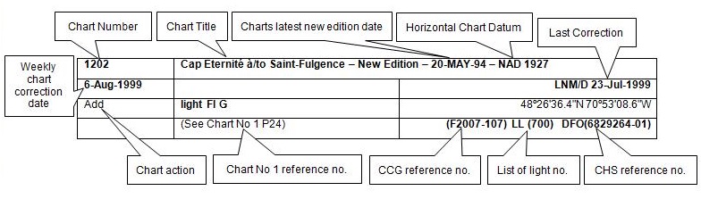
The last correction number is identified with the LNM/D or Last Notice to Mariners Number / Date.
Mariners are advised that only the most critical changes that directly affect safety to navigation are issued in “Section 2 – Chart Corrections.” This limitation is required to ensure that charts remain as clear and easy to read as possible. As a result, mariners may see minor discrepancies of a non-critical nature between information in official publications. For example, a small change in the nominal range or focal height of a light may not result in the production of a chart correction in Notices to Mariners, but may result in a correction in the List of Lights, Buoys and Fog Signals publication.
Note: In the case of a discrepancy between information provided on CHS charts relating to aids to navigation, and the List of Lights, Buoys and Fog Signals publication, the latter shall be deemed as containing the most up-to-date information.
Canadian Nautical Charts & Publications
A source list of Canadian nautical charts and publications is published in Notice No. 14 of the Notices to Mariners Annual Edition 2024. The source supply and the prices effective at the time of printing are listed. For current chart edition dates, please refer to the following website: www.chs-shc.gc.ca/charts-cartes/paper-papier/index-eng.asp
Explanatory Notes – Marine Communications and Traffic Services (MCTS)
Navigational Warnings / Notices to Shipping
The Canadian Coast Guard (CCG) is implementing a number of changes to the aids to navigation system in Canada.
These changes are advertised as Navigational Warnings, formerly called Notices to ShippingFootnote 1, that are broadcast by the CCG, and are then followed up with Notices to Mariners, then charts are updated by hand correction, reprints or new editions.
Mariners are advised that all relevant Navigational Warnings (NAVWARN) should be kept until superseded by Notices to Mariners or through revised charts issued by the Canadian Hydrographic Service (CHS).
NAVWARN are accessible on the applicable regional page on the CCG Navigational Warnings website at http://nis.ccg-gcc.gc.ca.
CHS is reviewing the impact of these changes with CCG and together are preparing an action plan on the issuing of chart revisions.
For further information, contact your regional NAVWARN Issuing Desk.
Western Region
Prince Rupert MCTS Centre
Canadian Coast Guard
Bag 4444
Prince Rupert, BC V8J 4K2
Telephone: 250-627-3070
Email: NAVWARN.MCTSPrinceRupert@innav.gc.ca
Website: http://www.marinfo.gc.ca/e-nav
Arctic Region
* Iqaluit MCTS Centre
Operational from approximately mid-May until late December.
“A” Series NAVWARN
Canadian Coast Guard
P.O. Box 189
Iqaluit, NU X0A 0H0
Telephone: 867-979-5269
Facsimile: 867-979-4264
Email: NAVWARN.MCTSIqaluit@innav.gc.ca
* Service available in English and French.
Index
Numerical Index of Canadian Charts Affected
This numerical index lists all nautical charts mentioned in this monthly edition of Notices to Mariners. Only charts appearing in Section 2 of this publication require a chart correction. The appearance of charts in all other sections, particularly those related to the correction of other nautical publications, is included here for reference.
| 3000 | 3489 | 3548 | 3859 |
| 3001 | 3493 | 3549 | 3895 |
| 3441 | 3512 | 3601 | 3902 |
| 3458 | 3514 | 3604 | 3935 |
| 3462 | 3534 | 3744 | 3957 |
| 3479 | 3535 | 3811 | 3981 |
| 3488 | 3546 | 3816 |
SECTION 1 - GENERAL AND SAFETY INFORMATION
*505/23Canadian Hydrographic Service – Magnetic Declination Calculations
(Recurrent publication of notice *505/23, originally published in the Notices to Mariners – Monthly Western Edition 05/2023 publication.)
Mariners are advised that CHS has adopted the harmonized World Magnetic Model (WMM), as found on the NCEI/NOAA website. Old compass rose declination information on CHS navigational products can be updated using the Magnetic Declination Estimated Value website. While the differences in the model declinations are small each year, they can become more significant over a large period of time.
*1004/23Transport Canada – British Columbia North Coast Waterway Management Guidelines
(Recurrent publication of notice *1004/23, originally published in the Notices to Mariners – Monthly Western Edition 10/2023 publication.)
Reference: Notice *905/22 is cancelled.
The North Coast Waterway Management Guidelines are voluntary guidelines that aim to improve safety on the water by reducing conflicts between First Nations’ marine use activities, such as fishing and shoreline harvesting, and commercial vessels on the shipping route between Kitimat and Browning Entrance. The guidelines came into effect on September 1, 2022, and will be reviewed from time to time.
The guidelines apply to all vessels navigating on the route between Kitimat and Browning Entrance, on the north coast of British Columbia. This area includes:
|
•Douglas Channel |
•Otter Channel |
|
•Wright Sound |
•Nepean Sound, and |
|
•Lewis Passage |
•Principe Channel |

The complete guidelines document is available at the following link:
Nothing in these guidelines replaces or changes how we apply any Canadian or international laws or regulations, including the Collision Regulations. Furthermore, nothing in these guidelines prevents or limits the master or pilot of a ship from making any decisions to protect the vessel, the crew, or the marine environment.
The guidelines include information for:
•all vessels that covers:
-inshore safety zones
-routing measures
-speed reductions
-guidelines for meeting and passing
-a special operating area in Wright Sound, and
-guidelines in case of a mechanical or electrical
breakdown
•large commercial ships, including bulk carriers,
general cargo vessels, liquid bulk vessels, and passenger
vessels
•tugs and barges, and
•vessels operating in First Nations Areas of Concern where you must pay special attention to make sure local community users can transit and use the area safely.
*1207/23Canadian Hydrographic Service – Inappropriate Geographical Names Review Process
(Recurrent publication of notice *1207/23, originally published in the Notices to Mariners – Monthly Western Edition 12/2023 publication.)
The records of the Canadian Hydrographic Service could contain geographical names that may be considered inappropriate, offensive and derogatory. Geographical naming authorities are in the process of addressing many offensive place names, the review process is underway. For more information, about inappropriate geographical names, please see the following announcement.
*208/24West Coast Haida Gwaii – Voluntary Protection Zone for Shipping
(Recurrent publication of notice *208/24, originally published in the Notices to Mariners – Monthly Western Edition 02/2024 publication.)
Reference: Notice *1105/21 is cancelled.
Voluntary Protection Zone for Shipping, western shore
of Haida Gwaii
(formerly Queen Charlotte Islands)
Haida Gwaii’s remote location, rugged coastline, variable sea and weather conditions, and rich ecological and cultural heritage make it vulnerable to the potential for pollution from shipping breakdowns and accidents. Increasing the distance vessels travel offshore can increase the amount of time available to address propulsion, steering or other issues, and the likelihood of a towing vessel being able to respond to a vessel in distress or drifting. This in turn reduces the risk of grounding and oil spills.
A Voluntary Protection Zone for Shipping on the western shore of Haida Gwaii is currently in effect. In the Voluntary Protection Zone, commercial vessels of 500 gross tonnage or greater are requested to observe a minimum distance of 50 nautical miles from the western shore of Haida Gwaii with the following exemptions:
Exemptions from requested 50 nm distance:
•Cruise vessels, which are asked to observe a minimum
12 nm distance from shore;
•Vessels transiting from Alaska to British Columbia or
Washington State, or vice versa, through the Voluntary
Protection Zone are asked to observe a distance of at least
25 nm from shore
•No minimum distance is requested for tugs and barges
(including pushing and towing alongside) or vessels engaged
in commercial fishing.
•Vessels to which this bulletin applies are not required to observe requested minimum distances if doing so may compromise navigational, vessel, passenger or cargo safety.
The Voluntary Protection Zone for Shipping coordinates are:
|
54⁰ 15.436' N |
133⁰ 04.788' W |
|
54⁰ 17.572' N |
134⁰ 02.484' W |
|
54⁰ 13.614' N |
134⁰ 19.427' W |
|
54⁰ 11.786' N |
134⁰ 30.841' W |
|
53⁰ 44.036' N |
134⁰ 32.677' W |
|
53⁰ 11.118' N |
134⁰ 16.412' W |
|
52⁰ 18.483' N |
133⁰ 20.917' W |
|
51⁰ 24.590' N |
132⁰ 04.081' W |
|
51⁰ 56.158' N |
131⁰ 01.830' W |
Vessels are requested to adhere to these distances on a voluntary basis and only when it does not jeopardize the safety of navigation, the vessel, the persons onboard, and the cargo.

*304/24Canadian Hydrographic Service – Chart 3895 Partially Replaced by New Chart 3816
(Recurrent publication of notice *304/24, originally published in the Notices to Mariners – Monthly Western Edition 03/2024 publication.)
Chart 3895, Plans – Dixon Entrance, has been partially replaced by new chart 3816, Parry Passage. The plan titled Parry Passage is now cancelled. The remaining plans will be cancelled at a later date.
*402/24Canadian Hydrographic Service – Nautical Charts
|
Charts |
Main Title |
Scale |
Edition Date |
Published |
Cat# |
Price |
|
New Charts |
||||||
|
3816 |
Parry Passage |
1:22 000 |
2024-02-02 |
2024-04-26 |
2 |
$20.00 |
|
Charts Permanently Withdrawn |
||||||
|
3859 |
Tasu Sound |
|
||||
*403/24Canadian Hydrographic Service – Electronic Navigational Charts
|
S-57 ENC Number |
Chart Title |
ENC Compilation Scale |
Published |
|
New Charts |
|||
|
CA370766 (Edn 1.000) |
Saanich to Point Roberts |
1:45 000 |
2024-04-26 |
|
CA571158 (Edn 1.000) |
Murchison-Faraday Passage |
1:6 000 |
2024-04-19 |
|
CA58PKVA (Edn 1.000) |
CA58PKVA |
1:11 000 |
2024-04-12 |
|
CA58PKWA (Edn 1.000) |
CA58PKWA |
1:11 000 |
2024-04-12 |
|
CA58PKXA (Edn 1.000) |
CA58PKXA |
1:6 000 |
2024-04-12 |
|
CA58QKWA (Edn 1.000) |
CA58QKWA |
1:11 000 |
2024-04-12 |
|
CA58QKXA (Edn 1.000) |
CA58QKXA |
1:11 000 |
2024-04-12 |
|
CA595L0A (Edn 1.000) |
CA595L0A |
1:11 000 |
2024-04-05 |
|
New Editions |
|||
|
CA44UN4A (Edn 2.000) |
Transit4800N07100W |
1:11 000 |
2024-04-05 |
|
CA44UNEA (Edn 2.000) |
Transit4800N07000W |
1:22 500 |
2024-04-05 |
|
CA46CRFA (Edn 2.000) |
CA46CRFA |
1:45 000 |
2024-04-05 |
|
CA46CRRA (Edn 2.000) |
CA46CRRA |
1:45 000 |
2024-04-19 |
|
CA46NRRA (Edn 2.000) |
CA46NRRA |
1:45 000 |
2024-04-19 |
|
CA471221 (Edn 2.000) |
CA471221 |
1:22 500 |
2024-04-12 |
|
CA54VNGA (Edn 2.000) |
Port4810N06980W |
1:2 000 |
2024-04-05 |
|
CA553Q2A (Edn 2.000) |
Port4880N06460W |
1:4 000 |
2024-04-05 |
|
CA553Q3A (Edn 2.000) |
Port4880N06450W |
1:4 000 |
2024-04-05 |
|
CA553Q4A (Edn 2.000) |
Port4880N06440W |
1:4 000 |
2024-04-05 |
|
CA571157 (Edn 2.000) |
Windy Bay |
1:11 000 |
2024-04-12 |
|
CA576003 (Edn 14.000) |
Halifax Harbour - Point Pleasant to/à Bedford Basin |
1:5 000 |
2024-04-26 |
|
Charts Permanently Withdrawn |
|||
|
CA573372 |
Ivujivik |
|
|
|
CA573374 |
Akulivik |
Cancelled by CA58QKXA,CA58QKWA,CA58PKXA |
|
*404/24Canadian Hydrographic Service – Raster Digital Charts (BSB V3)
|
Charts |
Main Title |
Scale |
Edition Date |
Published |
|
|
Charts Permanently Withdrawn |
|||||
|
RM-3859 |
Tasu Sound |
|
|
||
*405/24Transport Canada – Ship Safety Bulletin #09 and #10/2024
New Ship Safety Bulletins have recently been
posted on the
Transport Canada website.
To view or download these bulletins, please click on the
links below:
SSB#09/2024 – New and existing
insurance requirements for some
vessels
RDIMS#
20166820
SSB#10/2024 – Protecting the
North Atlantic right whale: Speed restriction measures in the
Gulf of St.
Lawrence
RDIMS#
18265176
Sign up for
e-Bulletin to receive an e-mail notice each time a new
Ship Safety Bulletin is published on our website.
Contact us at marinesafety-securitemaritime@tc.gc.ca
or 1-855-859-3123 (Toll Free).
*408/24Canadian Coast Guard Publication - Amendments to the Notices to Mariners Annual Edition 2024 - Section E, Notice 31: Reporting Marine Occurrences
Page 1:
AMEND AS FOLLOWS:
|
Location |
Address |
Phone |
Facsimile |
|
|
Atlantic |
150 Thorne Avenue |
902-471-0820 |
819-997-2239 |
|
|
Central |
2575 Ste-Anne
Boulevard, |
418-580-3510 |
819-997-2239 |
|
|
Pacific |
# 4 - 3071 Number Five Road |
604-219-2414 |
819-997-2239 |
*409/24Canadian Hydrographic Service – Chart 3811 Permanently Withdrawn
Chart 3811, Harbours in Queen Charlotte Islands/Havres dans Îles de la Reine-Charlotte, has been permanently cancelled.
Section 1A: Temporary and Preliminary Notices
Reminder – Comment Period for Active Preliminary Notices
No notices applicable for this edition.
Inland Waters
Temporary Notices
No notices applicable for this edition.
Preliminary Notices
No notices applicable for this edition.
Pacific Coast
Temporary Notices
No notices applicable for this edition.
Preliminary Notices
No notices applicable for this edition.
SECTION 2 - CHART CORRECTIONS
3000 - Juan de Fuca Strait to/à Dixon Entrance - New Edition - 20-JAN-1989 - NAD 1927
Download Patch - https://www.notmar.gc.ca/chsftp/patches/3000_6204908_1_202403141125.pdf
3001 - Vancouver Island / Île de Vancouver, Juan de Fuca Strait to/à Queen Charlotte Sound - New Edition - 23-FEB-2001 - NAD 1927
Download Patch - https://www.notmar.gc.ca/chsftp/patches/3001_6204908_1_202403141354.pdf
3441 - Haro Strait, Boundary Pass and/et Satellite Channel - New Edition - 01-JUL-2005 - NAD 1983
(See Chart 1, L25)
(See Chart 1, L25)
(See Chart 1, F16)
48°39′01.3″N 123°33′08.4″W
and 48°38′59.5″N 123°33′08.4″W
(See Chart 1, F16)
and 48°39′01.7″N 123°33′06.2″W
(See Chart 1, F16)
and 48°39′02.0″N 123°33′02.5″W
(See Chart 1, F16)
48°38′59.4″N 123°33′00.7″W
and 48°39′01.8″N 123°33′00.7″W
(See Chart 1, P1)
(See Chart 1, P1)
(See Chart 1, P1)
(See Chart 1, P1)
(See Chart 1, S4)
(See Chart 1, S4)
(See Chart 1, S4)
to 48°41′13.8″N 123°29′22.6″W
(See Chart 1, S4)
(See Chart 1, S4)
(See Chart 1, S4)
(See Chart 1, S4)
(See Chart 1, Qc)
to 48°34′45.2″N 123°10′46.7″W
3462 - Juan de Fuca Strait to/à Strait of Georgia - New Edition - 01-JUL-2005 - NAD 1983
(See Chart 1, S4)
(See Chart 1, S4)
(See Chart 1, S4)
(See Chart 1, S4)
(See Chart 1, S3.1)
(See Chart 1, Q9)
(See Chart 1, S3.1)
3479 - Approaches to/Approches à Sidney - New Chart - 18-MAY-2007 - NAD 1983
(See Chart 1, S4)
(See Chart 1, S4)
(See Chart 1, S4)
(See Chart 1, S4)
(See Chart 1, P1)
to 48°41′28.3″N 123°23′17.6″W
(See Chart 1, S4)
(See Chart 1, S4)
3479 - Iroquois Passage and/et John Passage - New Chart - 18-MAY-2007 - NAD 1983
(See Chart 1, S4)
(See Chart 1, S4)
(See Chart 1, P1)
to 48°41′28.3″N 123°23′17.6″W
3488 - Crescent Island to/à Strawberry Island - Sheet/Feuille 1 - New Chart - 21-OCT-1994 - NAD 1983
(See Chart 1, I10)
(See Chart 1, I10)
(See Chart 1, I10)
(See Chart 1, I10)
(See Chart 1, I10)
(See Chart 1, I10)
(See Chart 1, I10)
(See Chart 1, I10)
(See Chart 1, I10)
3489 - Barnston Island to/à Crescent Island - Sheet/Feuille 2 - New Chart - 21-OCT-1994 - NAD 1983
(See Chart 1, I10)
(See Chart 1, I10)
(See Chart 1, I10)
(See Chart 1, I10)
(See Chart 1, I10)
(See Chart 1, K26)
3493 - Vancouver Harbour Western Portion/Partie Ouest - New Edition - 15-NOV-2019 - World Geodetic System 1984
(See Chart 1, L41.1)
and 49°18′18.4″N 123°07′45.7″W
(See Chart 1, L41.1)
49°18′16.3″N 123°07′46.7″W
49°18′18.1″N 123°07′46.5″W
49°18′21.2″N 123°07′43.0″W
and 49°18′21.8″N 123°07′42.9″W
3512 - Strait of Georgia, Central Portion/Partie Centrale - New Edition - 25-DEC-1998 - NAD 1983
Download Patch - https://www.notmar.gc.ca/chsftp/patches/3512_6204908_5_202403141128.pdf
3514 - Jervis Inlet - New Edition - 02-AUG-1996 - NAD 1983
Download Patch - https://www.notmar.gc.ca/chsftp/patches/3514_6204908_4_202403141125.pdf
3535 - Pender Harbour - New Edition - 08-MAR-2019 - World Geodetic System 1984
(See Chart 1, N49)
and 49°37′43.4″N 124°04′56.0″W
Download Patch - https://www.notmar.gc.ca/chsftp/patches/3535_6204908_5_202403141128.pdf
(See Chart 1, N49)
and 49°38′14.0″N 124°04′21.0″W
3548 - Queen Charlotte Strait, Central Portion/Partie Centrale - New Edition - 26-SEP-1997 - NAD 1983
(See Chart 1, L30.1)
50°47′15.7″N 127°25′49.7″W
50°47′53.5″N 127°25′40.7″W
50°48′24.8″N 127°25′50.8″W
and 50°51′05.5″N 127°30′00.0″W
(See Chart 1, L30.1)
50°47′27.2″N 127°29′46.6″W
50°46′43.4″N 127°26′54.5″W
50°46′38.9″N 127°26′50.3″W
50°46′35.1″N 127°26′50.0″W
and 50°46′30.5″N 127°26′52.0″W
3549 - Queen Charlotte Strait Western Portion/Partie Ouest - New Chart - 03-DEC-1993 - NAD 1983
(See Chart 1, L30.1)
and 50°46′46.6″N 127°26′30.0″W
(See Chart 1, L30.1)
50°51′00.3″N 127°29′50.6″W
50°51′30.6″N 127°30′53.0″W
50°51′31.8″N 127°31′02.9″W
50°52′13.4″N 127°33′14.4″W
50°52′07.9″N 127°34′55.4″W
50°52′02.7″N 127°35′10.8″W
50°51′53.8″N 127°35′45.9″W
50°51′38.0″N 127°36′26.0″W
and 50°51′37.7″N 127°36′30.9″W
(See Chart 1, L30.1)
50°51′55.9″N 127°36′27.0″W
50°51′59.4″N 127°36′32.9″W
50°52′11.3″N 127°37′16.3″W
50°52′17.9″N 127°37′32.0″W
50°52′27.1″N 127°38′02.6″W
50°52′47.6″N 127°38′29.4″W
50°52′59.8″N 127°39′01.4″W
50°53′01.3″N 127°39′33.1″W
50°52′56.6″N 127°39′34.1″W
50°52′41.9″N 127°39′25.4″W
50°51′39.8″N 127°39′06.5″W
50°51′27.2″N 127°38′57.2″W
50°51′14.2″N 127°38′49.5″W
50°50′48.5″N 127°38′23.8″W
50°50′34.4″N 127°38′21.9″W
50°50′07.5″N 127°38′33.8″W
50°50′00.5″N 127°38′30.6″W
50°49′26.5″N 127°37′59.6″W
50°49′10.1″N 127°37′21.0″W
50°48′38.5″N 127°36′34.5″W
50°47′49.4″N 127°32′26.9″W
50°47′27.2″N 127°29′46.6″W
50°46′43.4″N 127°26′54.5″W
50°46′38.9″N 127°26′50.3″W
50°46′35.1″N 127°26′50.0″W
and 50°46′30.5″N 127°26′52.0″W
3601 - Juan de Fuca Strait to/à Vancouver Harbour - New Edition - 01-JUL-2005 - NAD 1983
(See Chart 1, S3.1)
(See Chart 1, S3.1)
3744 - Queen Charlotte Sound - New Edition - 20-MAY-1988 - NAD 1927
(See Chart 1, L25)
3902 - Hecate Strait - New Edition - 09-DEC-1988 - NAD 1927
(See Chart 1, L25)
(See Chart 1, L25)
3935 - Hakai Passage and Vicinity/et Environs - New Chart - 28-JAN-2000 - NAD 1983
(See Chart 1, L25)
3957 - Approaches to/Approches à Prince Rupert Harbour - New Edition - 07-OCT-2016 - World Geodetic System 1984
(See Chart 1, L25)
(See Chart 1, L25)
3981 - Laredo Channel and/et Laredo Inlet - New Chart - 19-APR-2013 - NAD 1983
(See Chart 1, L25)
SECTION 3 - RADIO AIDS TO MARINE NAVIGATION CORRECTIONS
*415/24Radio Aids to Marine Navigation 2024 (Atlantic, St. Lawrence, Great Lakes, Lake Winnipeg, Arctic and Pacific)
Page 2-64
AMEND AS FOLLOWS:
Table 2-31 - Radar Beacons Located in Newfoundland
|
Name and Location |
Identifier |
Remarks |
|
… |
… |
… |
|
Grappling Island Light
|
─ ─ • |
Navigation season only. |
|
Hens and Chickens
56°30'39.5"N |
• ─ ─ |
Open year round. |
|
Negro Island Light
56°21'05.8"N |
─ ─ • • |
Open year round. |
|
Quaker Hat
54°44'12.5"N |
─ ─ • ─ |
|
|
White Bear Island (Nanuaktok)
55°26'00.7"N |
─ • |
Navigation season only. |
Page 2-72 to 2-73
AMEND AS FOLLOWS:
Table 2-39 - Radar Beacons Located in Yukon
|
Name and Location |
Identifier |
Remarks |
|
Calton Point
|
─ ─ • |
Navigation season only. |
|
Collinson Head
69°34'30"N |
─ • |
Navigation season only. |
|
Kay Point
|
─ • ─ |
Navigation season only. |
|
Shingle Point
|
─ • ─ ─ |
Navigation season only. |
Table 2-41 - Radar Beacons Located in Northwest Territories
|
Name and Location |
Identifier |
Remarks |
|
Atkinson Point
69°56'46.7"N |
─ • ─ ─ |
Navigation season only. |
|
Baillie Islands
70°37'38.7"N |
─ • ─ |
Navigation season only. |
|
Cape Dalhousie
70°16'05"N |
─ ─ • • |
Navigation season only. |
|
Hardisty Island
61°43'52.6"N |
─ ─ • |
Navigation season only. |
|
Pelly Island
69°37'26.2"N |
─ • ─ ─ |
Navigation season only. |
|
Pilot Islands
62°13'04"N |
─ • ─ • |
Navigation season only. |
|
Pitt Island
69°09'15"N |
─ • ─ |
Navigation season only. |
|
Pullen Island
69°46'24.4"N5 |
─ ─ • |
Navigation season only. |
|
Relief Islet
70°08'45"N |
─ ─ • |
Navigation season only. |
|
Tuktoyaktuk Island
69°27'21.2"N |
─ • ─ • |
Navigation season only. |
|
Warren Point
69°45'00"N |
─ • ─ • |
Navigation season only. |
Page 2-73 to 2-74
AMEND AS FOLLOWS:
Table 2-42 - Radar Beacons Located in Nunavut
|
Name and Location |
Identifier |
Remarks |
|
Beacon Island
58°54'07.9"N |
─ ─ • |
Navigation season only. |
|
Broomfield Island
|
─ • |
Navigation season only. |
|
Cache Point
68°39'26.2"N |
─ ─ • |
Navigation season only. |
|
Cape Bexley
69°00'47"N |
─ • ─ ─ |
Navigation season only. |
|
Coats Island
|
─ • ─ • |
Navigation season only. |
|
Delta Island
68°35'15.3"N |
─ ─ • |
Navigation season only. |
|
Kitdliat Island
59°58'34.5"N |
─ • ─ |
Navigation season only. |
|
Mansel Island
|
─ • ─ |
Navigation season only. |
|
McClintock Point
69°18'34.2"N |
─ • ─ • |
Navigation season only. |
|
Nipper Island
59°00'26.5"N |
─ ─ • |
Navigation season only. |
|
Nordenskiold Islands
68°21'01.5"N |
─ • ─ |
Navigation season only. |
|
Nottingham Island
|
─ • |
Navigation season only. |
|
… |
… |
… |
Table 2-43 - Radar Beacons Located in Nunavik
|
Name and Location |
Identifier |
Remarks |
|
Pointe Qirniraujaq
58°35'00.6"N |
─ • • ─ |
Navigation season only. |
|
Puvirnituq
|
• ─ ─ • |
Navigation season only. |
Page 4-6
AMEND
4.1.2.2 The Alarm Signal
TO READ:
4.1.2.2 The Alarm Signal
The radiotelephony Audio Alarm Signal consists of a two tone
audio transmission followed by a ten second continuous tone.
The two tones are different pitches, similar to the sound of
emergency vehicles, and the ten second continuous tone
indicates that the transmission is from an MCTS Centre.
The Audio Alarm Signal is used to alert mariners that:
a)A distress call or distress message is about to
follow;
b)There is a new warning pertaining to a dangerous
weather phenomena (only the initial broadcast)
c)A tsunami warning broadcast is about to follow (only
the initial broadcast); or,
d)There has been an observed or reports of a dangerous weather phenomena, such as a waterspout.
Page 4-63
AMEND
4.3.3 World-Wide Navigational Warning Service (WWNWS)
TO READ:
4.3.3 World-Wide Navigational Warning Service
(WWNWS)
4.3.3.1 NAVAREAS XVII and
XVIII: Navigational Warnings
The Canadian Coast Guard has assumed responsibility of NAVAREA coordination for NAVAREAs XVII and XVIII as part of the World-Wide Navigational Warning Service (WWNWS).
Under the WWNWS, navigational warnings containing urgent
information relevant to safe navigation that are broadcast in
accordance with the Chapter IV of the International Convention
for the Safety of Life at Sea (SOLAS).
NAVAREA warnings, which contain information specific to ocean
going mariners, remain in force until cancelled or promulgated
by other means.
NAVAREA XVII and XVIII warnings that are less than 42 days old
are promulgated via SafetyNET II and SafetyCast.
The complete text of all In-Force NAVAREA warnings is available
from
the Canadian Coast Guard website.
Alternatively, these may be requested by forwarding an email to
the NAVAREA Operations desk at: navarea17.18@innav.gc.ca.
Figure 4-13 - Canadian NAVAREA Zones and Broadcast Areas

The map portrayed in figure 4-13 is of Northern Canada. Shown are the zones for NAVAREA XVII in red and NAVAREA XVIII in green. These position limits are detailed in Table 4-14.
Table 4-14 – NAVAREA* Coordinates
|
NAVAREA XVII |
NAVAREA XVIII |
|
67°00N 168°58W |
67°00N 120°00W |
|
90°00N 168°58W |
90°00N 120°00W |
|
90°00N 120°00 |
90°00N 035°00W |
|
67°00N 120°00W |
67°00N 035°00W |
*The geographical sea area contained with these coordinates which may include inland seas, lakes and waterways navigable by sea-going ships
During the Arctic navigational season, NAVAREA XVII and XVIII warnings applicable to the Canadian Search and Rescue boundaries for waters North of 70 degrees latitude are broadcast from Iqaluit (with limits to coverage area and reliability) using High Frequency Narrow Band Direct Printing (HF NBDP) on 8416.5 kHz at 03:30 UTC and 15:30 UTC. Refer to Iqaluit MCTS in Part 2 for details about the broadcast content.,
Table 4-15 - Broadcast Schedule
|
Hour UTC |
Service |
Frequency, Satellite, or System |
|
0330 |
HF NBDP |
8416.5 kHz* |
|
1100 |
NAV XVIII |
AOR-E, AOR-W SafetyCast |
|
1130 |
NAV XVII |
AOR-W, POR, SafetyCast |
|
1530 |
HF NBDP |
8416.5 kHz* |
|
2300 |
NAV XVIII |
AOR-E, AOR-W, SafetyCast |
|
2330 |
NAV XVII |
AOR-W, POR, SafetyCast |
*Available during Arctic navigational season
Comments concerning the reception of NAVAREA XVII and XVIII broadcasts, especially above 75°N, would be appreciated and should be sent to:
NAVAREA XVII and XVIII
Prescott MCTS Centre
Telephone:613-925-0666
Facsimile: 613-925-4519
E-mail: navarea17.18@innav.gc.ca
Page 4-64
AMEND
4.3.3.1.1 SafetyNET
TO READ:
4.3.3.1.1 Inmarsat C- SafetyNET II
NAVAREAs XVII and XVIII warnings are broadcast in the English
language directly into the appropriate GMDSS NAVAREA zone, with
a broadcast overlap of 300 NM.
To learn more about the
Inmarsat SafetyNET service, please consult their website or
the SafetyNET manual (MSC.1/Circ.1364/Rev.2).
ADD AS FOLLOWS:
4.3.3.1.2 Iridium - SafetyCast
SECTION 4 - CANADIAN SAILING DIRECTIONS CORRECTIONS
The following Canadian Sailing Directions volumes have recently been updated on the Canadian Hydrographic Service website.
|
No. |
Title |
|
Atlantic Coast |
|
|
ATL105 |
Cape Canso to Cape Sable (including Sable Island) |
Each volume includes a section entitled “Record of Changes” which lists all updates that are incorporated during the current calendar year.
SECTION 5 - LIST OF LIGHTS, BUOYS AND FOG SIGNALS CORRECTIONS
The amendments are highlighted and deletions are crossed out. For general and region-specific
information on the List of Lights, click on the following links:
Newfoundland and Labrador Coast,
Atlantic Coast,
Inland Waters and
Pacific Coast.
PACIFIC COAST
| No. | Name |
Position ----- Latitude N. Longitude W. |
Light Characteristics |
Focal Height in m. above water |
Nominal Range |
Description ----- Height in meters above ground |
Remarks ----- Fog Signals |
|||
|---|---|---|---|---|---|---|---|---|---|---|
WEST COAST, VANCOUVER ISLAND (LL 66 – 179.1) |
||||||||||
| 87.5 | South Brooks ODAS light buoy 46132 |
W. of Kyuquot
Sound. 49 46 15.6 127 52 56.0 |
Fl(5) | Y | 20s | ..... | ..... | Yellow ODAS, marked “46132”. |
Year round. Chart:3604 Edn 04/24 (P24-015) |
|
HOWE SOUND (LL 417 – 432) |
||||||||||
|
427.1 427.2G5423.75 G5423.76 |
Squamish Terminal range |
| | | | | | | | | | |
49 41 12.1 019°30’ 122.2 m from front.
123 10 22.6 |
F
F
|
Y
Y
|
…..
…..
|
4.9
9.8
|
10
10
|
Square skeleton tower, white daymark with red vertical
stripe. 3-pile dolphin, white daymark with red vertical
stripe.
|
Operates 24 h. Operates 24 h.Year round. Year round. Chart:3534 Edn 04/24 (P24-020, 021) |
VANCOUVER ISLAND (LL 433 – 447.2) |
||||||||||
| 435.2 | Forwood Channel light buoy P0 |
SW. of Entrance
Island. 49 12 21.9 123 48 52.1 |
Q | R | 1s | ….. | ….. | Red, marked “P0”. |
Year
round. Chart:3458 Edn 04/24 (P24-019) |
|
BROUGHTON STRAIT (LL 545 – 553.5) |
||||||||||
|
550.5 G5625 |
Haddington Island |
N. side of island. 50 36 18.1 127 01 16.4 |
Q | G | 1s | 7.6 | 5 | Square skeleton tower, green and white rectangular daymark. |
Radar
reflector. Year round. Chart:3546 Edn 04/24 (P24-018) |
|
QUEEN CHARLOTTE SOUND (LL 569.2 – 586) |
||||||||||
| 582.5 | West Sea Otter ODAS light buoy 46204 |
Off Calvert
Island. 51 24 14.2 128 41 06.3 |
Fl(5) | Y | 20s | ..... | ..... | Yellow ODAS, marked “46204”. |
Year round. Position in NAD 83. Chart:3744 Edn 04/24 (P24-007) |
|
Report a problem on this page
- Date modified: